Schouten Island

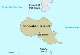
Map of Schouten Island
|
|
|
Location of Schouten Island in Tasmania
|
|
| Etymology | In honour of Joost Schouten, a member of the Council of the Dutch East India Company; named in 1642 by Abel Tasman. |
|---|---|
| Geography | |
| Location | East coast of Tasmania |
| Coordinates | 42°18′36″S 148°16′12″E / 42.31000°S 148.27000°ECoordinates: 42°18′36″S 148°16′12″E / 42.31000°S 148.27000°E |
| Archipelago | Schouten Island Group |
| Adjacent bodies of water | Tasman Sea |
| Area | 28 km2 (11 sq mi) |
| Highest elevation | 400 m (1,300 ft) |
| Highest point | Mount Storey |
| Administration | |
|
Australia
|
|
| State | Tasmania |
| Local government area | Glamorgan Spring Bay Council |
| Additional information | |
| Time zone | |
| • Summer (DST) | |
The Schouten Island (formerly Schouten's Isle), part of the Schouten Island Group, is an island with an area of approximately 28 square kilometres (11 sq mi) lying close to the eastern coast of Tasmania, Australia, located 1.6 kilometres (0.99 mi) south of the Freycinet Peninsula and is a part of Freycinet National Park.
Schouten Island lies within the territory of the Oyster Bay tribe of Tasmanian Aborigines and kitchen middens indicates Indigenous tribes inhabited the island prior to European settlement. In 1642, while surveying the south-west coast of Tasmania, Abel Tasman named the island after Joost Schouten, a member of the Council of the Dutch East India Company.
Members of the Baudin expedition landed on Schouten in 1802. In the early 19th century, sealers were active in the area and are known to have visited the island. The discovery of coal on the island in 1809 by a sealer, John Stacey led to between 1842 and 1925, several phases of coal and tin mining, where in 1880 a small number of Chinese men worked the ground for tin. Stacey found that 200 to 300 hectares (490 to 740 acres) of land could be suitable for cultivation. Plans to use convict labour to mine coal on the island in the 1840s were never realised. From 1850 Schouten was used for grazing sheep, with grazing leases only expiring in 1969.
Schouten is a rugged island with the highest point, Mount Storey, 400 metres (1,300 ft) above sea level. It is surrounded by cliffs, broken by sheltered bays. A north-south fault line exists divides the island where the eastern part of the island is composed of granite while the western part is dolerite overlying sedimentary and supergroup rocks.
...
Wikipedia

