Schofield, Wisconsin
| Schofield, Wisconsin | |
|---|---|
| City | |

Former Schofield School in Schofield
|
|
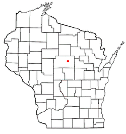
 Location of Schofield, Wisconsin |
|
| Coordinates: 44°54′55″N 89°36′43″W / 44.91528°N 89.61194°WCoordinates: 44°54′55″N 89°36′43″W / 44.91528°N 89.61194°W | |
| Country | United States |
| State | Wisconsin |
| County | Marathon |
| Area | |
| • Total | 2.83 sq mi (7.33 km2) |
| • Land | 1.76 sq mi (4.56 km2) |
| • Water | 1.07 sq mi (2.77 km2) |
| Elevation | 1,201 ft (366 m) |
| Population (2010) | |
| • Total | 2,169 |
| • Estimate (2012) | 2,152 |
| • Density | 1,232.4/sq mi (475.8/km2) |
| Time zone | Central (CST) (UTC-6) |
| • Summer (DST) | CDT (UTC-5) |
| Area code(s) | 715 & 534 |
| FIPS code | 55-72150 |
| GNIS feature ID | 1573796 |
| Website | cityofschofield |
Schofield is a city in Marathon County, Wisconsin, United States. It is part of the Wausau, Wisconsin Metropolitan Statistical Area. The population was 2,169 at the 2010 census.
Schofield is located along the eastern shore of Lake Wausau, an impoundment of the Wisconsin River. Schofield also contains the Eau Claire Flowage and Eau Claire River (not to be confused with the Eau Claire River of Eau Claire, WI), which flows into Lake Wausau at Schofield. Schofield is directly south of Wausau, and is generally separated from the city by the Wausau Downtown Airport. An inner suburb of Wausau, Schofield is bordered by Rothschild, Weston, and the Town of Weston. Lake Wausau and Wausau serve as its western and northern borders. Schofield is located at 44°54′55″N 89°36′43″W / 44.91528°N 89.61194°W (44.915201, -89.612004).
According to the United States Census Bureau, the city has a total area of 2.83 square miles (7.33 km2), of which, 1.76 square miles (4.56 km2) is land and 1.07 square miles (2.77 km2) is water.
As of the census of 2010, there were 2,169 people, 994 households, and 549 families residing in the city. The population density was 1,232.4 inhabitants per square mile (475.8/km2). There were 1,099 housing units at an average density of 624.4 per square mile (241.1/km2). The racial makeup of the city was 90.1% White, 1.2% African American, 0.8% Native American, 5.5% Asian, 0.2% from other races, and 2.2% from two or more races. Hispanic or Latino of any race were 1.8% of the population.
...
Wikipedia
