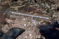
Schefferville Airport
| Schefferville Airport | |||||||||||
|---|---|---|---|---|---|---|---|---|---|---|---|
 |
|||||||||||
| Summary | |||||||||||
| Airport type | Public | ||||||||||
| Operator | Société aéroportuaire de Schefferville | ||||||||||
| Location | Schefferville, Quebec | ||||||||||
| Time zone | EST (UTC−05:00) | ||||||||||
| • Summer (DST) | EDT (UTC−04:00) | ||||||||||
| Elevation AMSL | 1,709 ft / 521 m | ||||||||||
| Coordinates | 54°48′19″N 066°48′19″W / 54.80528°N 66.80528°WCoordinates: 54°48′19″N 066°48′19″W / 54.80528°N 66.80528°W | ||||||||||
| Map | |||||||||||
| Location in Quebec | |||||||||||
| Runways | |||||||||||
|
|||||||||||
Schefferville Airport, (IATA: YKL, ICAO: CYKL), is located adjacent to the community of Schefferville, Quebec, Canada.
...
Wikipedia

