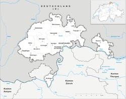
Schaffhausen (canton)
| Kanton Schaffhausen | ||
|---|---|---|
| Canton of Switzerland | ||
|
||
 Location in Switzerland |
||
| Coordinates: 47°43′N 8°34′E / 47.717°N 8.567°ECoordinates: 47°43′N 8°34′E / 47.717°N 8.567°E | ||
| Capital | Schaffhausen | |
| Subdivisions | 27 municipalities | |
| Government | ||
| • Executive | Regierungsrat (5) | |
| • Legislative | Kantonsrat (60) | |
| Area | ||
| • Total | 298.42 km2 (115.22 sq mi) | |
| Population (12/2015) | ||
| • Total | 79,836 | |
| • Density | 270/km2 (690/sq mi) | |
| ISO 3166 code | CH-SH | |
| Highest point | 912 m (2,992 ft): Hoher Randen | |
| Lowest point | 344 m (1,129 ft): Rhine at Buchberg | |
| Joined | 1501 | |
| Languages | German | |
| Website | SH.ch | |
The Canton of Schaffhausen (German: ![]() Schaffhausen ) is a canton of Switzerland. The principal city and capital of the canton is Schaffhausen.
Schaffhausen ) is a canton of Switzerland. The principal city and capital of the canton is Schaffhausen.
Schaffhausen was a city-state in the Middle Ages; it is documented that it struck its own coins starting in 1045. It was then documented as Villa Scafhusun. Around 1049 Count Eberhard von Nellenburg founded a Benedictine monastery which led to the development of a community. This community achieved independence in 1190. In 1330 the town lost not only all its lands but also its independence to the Habsburgs. In 1415 the Habsburg Duke Frederick IV of Austria sided with the Antipope John XXIII at the Council of Constance, and was banned by the Emperor Sigismund. As a result of the ban and Frederick's need of money, Schaffhausen was able to buy its independence from the Habsburgs in 1418. The city allied with six of the Swiss confederates in 1454 and allied with a further two (Uri and Unterwalden) in 1479. Schaffhausen became a full member of the Old Swiss Confederation in 1501. The first railroad came to Schaffhausen in 1857. In 1944 Schaffhausen suffered from a bombing raid by United States Army Air Forces planes that accidentally strayed from Germany into neutral Switzerland.
...
Wikipedia


