Sawyer, Oklahoma
| Sawyer, Oklahoma | |
|---|---|
| Town | |
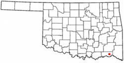
 Location of Sawyer, Oklahoma |
|
| Coordinates: 34°0′46″N 95°22′20″W / 34.01278°N 95.37222°WCoordinates: 34°0′46″N 95°22′20″W / 34.01278°N 95.37222°W | |
| Country | United States |
| State | Oklahoma |
| County | Choctaw |
| Area | |
| • Total | 8.8 sq mi (22.7 km2) |
| • Land | 8.6 sq mi (22.4 km2) |
| • Water | 0.1 sq mi (0.3 km2) |
| Elevation | 423 ft (129 m) |
| Population (2010) | |
| • Total | 321 |
| • Density | 37/sq mi (14.3/km2) |
| Time zone | Central (CST) (UTC-6) |
| • Summer (DST) | CDT (UTC-5) |
| ZIP code | 74756 |
| Area code(s) | 580 |
| FIPS code | 40-65650 |
| GNIS feature ID | 1097856 |
Sawyer is a town in Choctaw County, Oklahoma, United States. The population was 321 at the 2010 census.
Sawyer is located in eastern Choctaw County at 34°0′46″N 95°22′20″W / 34.01278°N 95.37222°W (34.012880, -95.372138). The town center is on the east side of the Kiamichi River at Hugo Dam. The town limits extend north up the east side of Hugo Lake and west to touch the southwest side of the lake.
U.S. Route 70 passes through the town, leading west 8 miles (13 km) to the city of Hugo, the Choctaw County seat, and east 6 miles (10 km) to Fort Towson.
According to the United States Census Bureau, the town of Sawyer has a total area of 8.8 square miles (22.7 km2), of which 8.6 square miles (22.4 km2) is land and 0.12 square miles (0.3 km2), or 1.13%, is water.
As of the census of 2000, there were 274 people, 115 households, and 80 families residing in the town. The population density was 59.0 people per square mile (22.8/km²). There were 127 housing units at an average density of 27.4 per square mile (10.6/km²). The racial makeup of the town was 76.28% White, 0.36% African American, 17.15% Native American, 0.73% from other races, and 5.47% from two or more races. Hispanic or Latino of any race were 1.46% of the population.
...
Wikipedia
