Satpula
| Satpula | |
|---|---|

Satpula (Seven arched bridge)
|
|
| Location | Delhi |
| Coordinates | 28°31′54.23″N 77°13′24.61″E / 28.5317306°N 77.2235028°ECoordinates: 28°31′54.23″N 77°13′24.61″E / 28.5317306°N 77.2235028°E |
| Construction began | 1343 AD |
| Dam and spillways | |
| Impounds | Barapulla Nallah |
| Length | 79.5 m (261 ft) |
| Reservoir | |
| Creates | Irrigation |
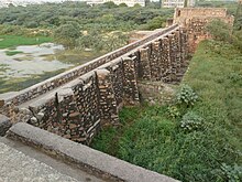
Satpula is a remarkable ancient water harvesting dam or weir located about 800 m (2,625 ft) east of the Khirki Masjid that is integral to the compound wall of the medieval fourth city of the Jahanpanah in Delhi, with its construction credited to the reign of Sultan Muhammad Shah Tughlaq (Muhammad bin Tughluq) (1325–1351) of the Tughlaq Dynasty.
The objective of building the weir was for providing water for irrigation and also, as a part of the city wall, to provide defense security to the city against attacking armies.
Satpula is a usage in Urdu and Hindi languages, which literally means "seven bridges".
During the second decade rule of Sultan Muhammad Shah Tughlaq, the economic conditions of the Delhi Sultanate was in distress due to very high expenses incurred on the war campaign in South India (Deccan) and also due to the Sultan establishing his southern capital at Daulatabad. Both these acts necessitated increasing taxes to enhance the treasury coffers to meet large expenses. But people were dissatisfied and distressed with these developments. Some tribal groups, such as the Chaghatai tribes, had rebelled, launched raids on many places in North India and even posed serious threats to Delhi, when the Sultan was on his south Indian campaign. In the period between 1334 and 1344, repeated droughts had caused famines that were further compounded by the Black Plague. These two natural calamities had added to the suffering of the people in the country. Urgent solutions had to be found to remedy the distress conditions. One of the viable options planned was of building the Satpula, the seven arches bridge or gate controlled weir/dam, to tap the water resources of the local nallah (stream) feeding the Yamuna river, which could be used to bring large areas of flat land in the vicinity under controlled irrigated agriculture to grow food crops to stem the famine conditions. This solution was also thought to provide the much needed defense to the walls of the newly built city of Jahanpanah.
...
Wikipedia
