Satartia, Mississippi
| Satartia, Mississippi | |
|---|---|
| Village | |

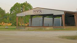
Processing gin in Satartia, 2011
|
|
 Location of Satartia, Mississippi |
|
| Location in the United States | |
| Coordinates: 32°40′13″N 90°32′46″W / 32.67028°N 90.54611°WCoordinates: 32°40′13″N 90°32′46″W / 32.67028°N 90.54611°W | |
| Country | United States |
| State | Mississippi |
| County | Yazoo |
| Area | |
| • Total | 0.1 sq mi (0.4 km2) |
| • Land | 0.1 sq mi (0.4 km2) |
| • Water | 0.0 sq mi (0.0 km2) |
| Elevation | 108 ft (33 m) |
| Population (2000) | |
| • Total | 68 |
| • Density | 454.5/sq mi (175.5/km2) |
| Time zone | Central (CST) (UTC-6) |
| • Summer (DST) | CDT (UTC-5) |
| ZIP code | 39162 |
| Area code(s) | 662 |
| FIPS code | 28-65680 |
| GNIS feature ID | 0690988 |
Satartia is a village in Yazoo County, Mississippi. The population was 68 at the 2000 census.
Located on the east bank of the Yazoo River, Satartia was once a thriving river port, and is one of the oldest non-Native settlements in Yazoo County.
Satartia is a Choctaw word meaning "pumpkin place", likely due to the small gourds that grow in the area.
In the early 1800s, Satartia was a busy shipping point from which cotton was transported by steamboat to New Orleans along the Yazoo River.
During the Civil War, General Grant sailed a gunboat from Vicksburg and captured the village; the Wilson House on Plum Street was used as his headquarters during the occupation. The war also produced the "Satartia Rifles", a well-regarded Confederate regiment and recruitment group.
Currently there is one small country grocery store and a cotton processing gin in Satartia. The Emmaus (Christian) Retreat Center is located at the nearby No Mistake Plantation.
According to the United States Census Bureau, the village has a total area of 0.2 square miles (0.52 km2), all land.
As of the 2010 United States Census, there were 55 people residing in the village. 89.1% were White, and 10.9% were Black or African American.
As of the census of 2000, there were 68 people, 28 households, and 22 families residing in the village. The population density was 454.5 people per square mile (175.0/km²). There were 32 housing units at an average density of 213.9 per square mile (82.4/km²). The racial make-up of the village was 85.29% White and 14.71% African American.
...
Wikipedia

