Sarangani Island
| Sarangani | |
|---|---|
| Municipality | |
| Nickname(s): The Paradise of the South; Southern Island of the Philippines; Gateway to Southern Philippines; Hot Springs Capital of Davao Occidental |
|
| Motto: " Sarangani Bayan Natin, Sarangani Paraiso Natin! " | |
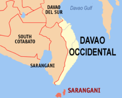
 Map of Davao Occidental with Sarangani highlighted |
|
| Location within the Philippines | |
| Coordinates: 05°24′N 125°28′E / 5.400°N 125.467°ECoordinates: 05°24′N 125°28′E / 5.400°N 125.467°E | |
| Country | Philippines |
| Region | Davao Region (Region XI) |
| Province | Davao Occidental |
| District | Lone District of Davao Occidental |
| Founded | 1980 |
| Barangays | 12 |
| Government | |
| • Mayor | Jerry T. Cawa |
| Area | |
| • Total | 97.72 km2 (37.73 sq mi) |
| Population (2015 census) | |
| • Total | 24,039 |
| • Density | 250/km2 (640/sq mi) |
| Time zone | PST (UTC+8) |
| ZIP code | 8015 |
| IDD : area code | +63 (0)82 |
| Income class | 4th municipal income class |
| 118605000 | |
| Electorate | 13,318 voters as of 2016 |
| Website | www |
Sarangani is a 4th class municipality in the province of Davao Occidental, Philippines. According to the 2015 census, it has a population of 24,039 people.
The municipality consists of 2 major islands (the eponymous Sarangani Island and Balut Island) and 1 minor islet (Olanivan Island), collectively called as the Sarangani Islands, located just south of Mindanao island in the Celebes Sea.
Sarangani is politically subdivided into 12 barangays.
Municipal officials 2013-2016:
...
Wikipedia

