Sarangani (province)
| Sarangani | ||
|---|---|---|
| Province | ||
| Province of Sarangani | ||
|
||
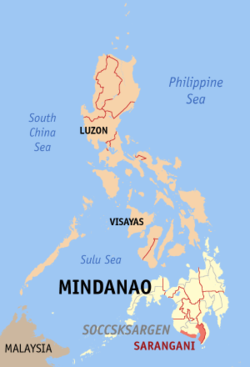
 Location in the Philippines |
||
| Coordinates: 5°52′N 125°17′E / 5.87°N 125.28°ECoordinates: 5°52′N 125°17′E / 5.87°N 125.28°E | ||
| Country | Philippines | |
| Region | Soccsksargen (Region XII) | |
| Founded | March 16, 1992 | |
| Capital | Alabel | |
| Government | ||
| • Type | Sangguniang Panlalawigan | |
| • Governor | Steve C. Solon (UNA/PCM) | |
| • Vice Governor | Elmer de Peralta | |
| • Congressman | Ruel Pacquiao | |
| • Sangguniang Panlalawigan |
Members
|
|
| Area | ||
| • Total | 3,601.25 km2 (1,390.45 sq mi) | |
| Area rank | 37th out of 81 | |
| Population (2015 census) | ||
| • Total | 544,261 | |
| • Rank | 55th out of 81 | |
| • Density | 150/km2 (390/sq mi) | |
| • Density rank | 58th out of 81 | |
| Divisions | ||
| • Independent cities | 0 | |
| • Component cities | 0 | |
| • Municipalities |
7
|
|
| • Barangays | 141 | |
| • Districts | Lone district of Sarangani | |
| Time zone | PST (UTC+8) | |
| ZIP code | 9501–9503, 9514–9517 | |
| IDD : area code | +63 (0)83 | |
| ISO 3166 code | PH-SAR | |
| Spoken languages | ||
| Website | www |
|
Sarangani, or Saraŋgani, is a province in the Philippines located in the Soccsksargen region. Its capital is Alabel. With a 230-kilometre (140 mi) coastline along the Sarangani Bay and Celebes Sea, the province is at the southernmost tip of Mindanao island, and borders South Cotabato and Davao del Sur to the north, Davao Occidental to the east, and the Celebes Sea to the south.
Sarangani is part of the South Cotabato-Cotabato-Sultan Kudarat-Sarangani-General Santos City (SOCCSKSARGEN) development cluster, and is linked by paved roads to the international airport and harbor of General Santos City.
The province is divided into two sections, separated by the Sarangani Bay and General Santos City, and it used to be part of South Cotabato until it was made an independent province in 1992.
The island of Sarangani (now part of Davao Occidental) was named by Spanish explorer Ruy López de Villalobos in 1543 as Antonia, in honor of Antonio de Mendoza y Pacheco who commissioned the Villalobos expedition to the Philippines. The early inhabitants who first inhabited Sarangani were the indigenous natives, called MunaTo, a native term for "first people."
In 1942, the Japanese troops occupied Southern Cotabato. In 1945, Filipino troops of the 6th, 10th, 101st and 102nd Infantry Division of the Philippine Commonwealth Army and 10th Infantry Regiment of the Philippine Constabulary entered in and liberated Southern Cotabato and fought against the Japanese Imperial Army forces during the Battle of Cotabato at the end of World War II under the Japanese Occupation.
...
Wikipedia

