Sara Sara
| Sara Sara | |
|---|---|

Sara Sara and Lake Parinacochas in front of it
|
|
| Highest point | |
| Elevation | 5,505 m (18,061 ft) |
| Prominence | 2,060 m (6,760 ft) |
| Listing | Ultra |
| Coordinates | 15°19′46″S 73°26′41″W / 15.32944°S 73.44472°WCoordinates: 15°19′46″S 73°26′41″W / 15.32944°S 73.44472°W |
| Geography | |
|
|
|
| Parent range | Andes |
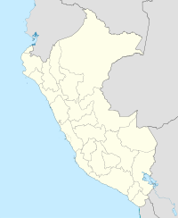
Sara Sara is a 5,505-metre-high (18,061 ft) volcano lying between Lake Parinacochas and Ocoña River in Peru. It is situated in the Parinacochas Province, Puyusca District, and in the Paucar del Sara Sara Province, in the districts of Pausa and Sara Sara.
The Spanish priest Cristobal de Albornoz noted in 1583 that Sara Sara was one of the most important sacred places in the southern part of Peru, with 2,000 colonists sent by the Inca emperor for its service. The American archaeologist Johan Reinhard surveyed a site on its summit in 1983 and he and Peruvian archaeologist Jose Antonio Chavez led a team that uncovered more than a dozen statues and a female Inca mummy (later nicknamed Sarita) on the summit in 1996. Their expedition was transmitted "live" over the Internet. The findings made on Sara Sara are currently stored at the Museo de Santuarios Andinos in Arequipa.
The archaeological group of Sara Sara was recommended to be declared a National Cultural Heritage in 2003.
Sara Sara and Lake Parinacochas (foreground) as seen from Inka Wasi
Reinhard, Johan (2005). The Ice Maiden: Inca Mummies, Mountain Gods, and Sacred Sites in the Andes. Washington, D.C.: National Geographic Society. .
...
Wikipedia

