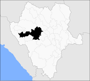
Santiago Papasquiaro Municipality
| Santiago Papasquiaro | |
|---|---|
| Municipality | |
 Municipality of Santiago Papasquiaro in Durango |
|
| Location in Mexico | |
| Coordinates: 25°03′N 105°29′W / 25.050°N 105.483°WCoordinates: 25°03′N 105°29′W / 25.050°N 105.483°W | |
| Country |
|
| State | Durango |
| Municipal seat | Santiago Papasquiaro |
| Area | |
| • Total | 7,238.4 km2 (2,794.8 sq mi) |
| Elevation | 1,730 m (5,675 ft) |
| Population (2010) | |
| • Total | 44,966 |
| • Density | 6.2/km2 (16/sq mi) |
| Time zone | CDT -5 |
Santiago Papasquiaro is one of the 39 municipalities of Durango, in north-western Mexico. The municipal seat lies at Santiago Papasquiaro. The municipality covers an area of 7,238.4 km². Santiago Papasquiaro municipality is at an average height of 1,730 m (5,675 ft) over the sea-level. The municipality lies east from Sierra Madre Occidental Mountain Range. It neighbors with other municipalities: Canelas and Tepehuanes municipalities at the north; San Dimas and Otáez, south; Nuevo Ideal to the east, Tamazula to the west and El Oro located northeast.
As of 2010, the municipality had a total population of 44,966, up from 41,539 as of 2005.
As of 2010, the city of Santiago Papasquiaro had a population of 26,121. Other than the city of Santiago Papasquiaro, the municipality had 416 localities, the largest of which (with 2010 populations in parentheses) were: Ciénega de Nuestra Señora de Guadalupe (1,720), and José María Morelos (Chinacates) (1,331), classified as rural.
Santiago Papasquiaro was very useful to conquer the territory of the main axis. It helped Tepehuanos to defend their territory from the Tarahumara and Chichimecan people. And by the other hand, the territory of Santiago Papasquiaro helped Spanish conquers, who understood the strategic of this land. Priest Jerónimo Ramírez understood the region's natives because they lived well-organized in comparison to the Zacatecos, Jerónimo Ramírez used to work more with the Tepehuano. Since Topia's conquering Spaniards got benefits from Aledaña mines; even when there was not a mission there.
La Sauceda settlement was built with the natives from El Valle de Anáhuac Valley separating the Tepehuano territory and El Valle del Guadiana Valley, the capital of Nueva Vizcaya province. The mission was founded in 1597, making Santiago Papasquiaro the center of the activities in all the Tepehuano territory.
In November 18, 1616, Santiago Papasquiaro's Spanish population and its church were attacked by the natives. Caciques led the attacks, one of them was Quitlatas. The resulting of the assault was in priests Bernardo Cisneros and Diego de Orozco deaths.
In 1620, a mission was established in the same place, even when natives used to strike them still. It was until 1690 when the town was officially established. In the XVIII century, the municipality was astounded by three droughts. After the recovery in 1787, the town was titled as a Village.
After Independence War, Santiago Papasaquiaro was recognized as the party capital, which lasted until the disappearance of the organization system in 1917.
...
Wikipedia

