Santa Paula, California
| City of Santa Paula | ||
|---|---|---|
| General law city | ||

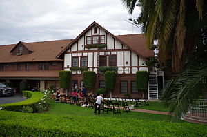
Historic Glen Tavern Inn, 2014
|
||
|
||
| Nickname(s): Citrus Capital of the World | ||
 Location in Ventura County and the state of California |
||
| Location in the United States | ||
| Coordinates: 34°21′21″N 119°4′6″W / 34.35583°N 119.06833°WCoordinates: 34°21′21″N 119°4′6″W / 34.35583°N 119.06833°W | ||
| Country |
|
|
| State |
|
|
| County | Ventura | |
| Founded | 1872 | |
| Incorporated | April 22, 1902 | |
| Government | ||
| • Mayor | Martin Hernandez | |
| • State senator | Hannah-Beth Jackson (D) | |
| • Assemblymember | Monique Limón (D) | |
| • U.S. rep. | Julia Brownley (D) | |
| Area | ||
| • City | 4.707 sq mi (12.189 km2) | |
| • Land | 4.593 sq mi (11.895 km2) | |
| • Water | 0.114 sq mi (0.294 km2) 2.41% | |
| Elevation | 279 ft (85 m) | |
| Population (April 1, 2010) | ||
| • City | 29,321 | |
| • Estimate (2013) | 30,091 | |
| • Density | 6,200/sq mi (2,400/km2) | |
| • Metro | 823,318 | |
| Time zone | Pacific (UTC−8) | |
| • Summer (DST) | PDT (UTC−7) | |
| ZIP codes | 93060, 93061 | |
| Area code | 805 | |
| FIPS code | 06-70042 | |
| GNIS feature IDs | 1652793, 2411826 | |
| Website | www |
|
Santa Paula is a city in Ventura County, California, United States. Situated amidst the orchards of the fertile Santa Clara River Valley, the city advertises itself to tourists as the "Citrus Capital of the World." Santa Paula was one of the early centers of California's petroleum industry. The Union Oil Company Building, the founding headquarters of the Union Oil Company of California in 1890, now houses the California Oil Museum. The population was 29,321 at the 2010 census, up from 28,598 at the 2000 census.
The area of what today is Santa Paula was originally inhabited by the Chumash, a Native American people. In 1769, the Spanish Portola expedition, first Europeans to see inland areas of California, came down the Santa Clara River Valley from the previous night's encampment near Fillmore and camped in the vicinity of Santa Paula on August 12, near one of the creeks coming into the valley from the north (probably Santa Paula Creek). Fray Juan Crespi, a Franciscan missionary travelling with the expedition, had previously named the valley Cañada de Santa Clara. He noted that the party traveled about 9 to 10 miles (14 to 16 km) that day and camped near a large native village, which he named San Pedro Amoliano. The site of the expedition's arrival has been designated California Historical Landmark No. 727.
Franciscan missionaries, led by Father Junipero Serra, became active in the area after the founding of the San Buenaventura Mission and established an Asistencia; the town takes its name from the Catholic Saint Paula. Santa Paula is located on the 1843 Rancho Santa Paula y Saticoy Mexican land grant.
...
Wikipedia


