Santa Maria dos Olivais
| Olivais | ||
|---|---|---|
| Parish | ||

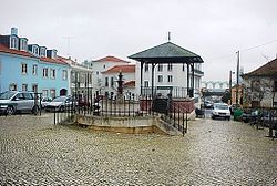
Praça da Viscondessa dos Olivais, in the old part of Olivais
|
||
|
||
 |
||
| Coordinates: 38°46′26″N 9°07′05″W / 38.774°N 9.118°WCoordinates: 38°46′26″N 9°07′05″W / 38.774°N 9.118°W | ||
| Country | Portugal | |
| Region | Lisbon | |
| Subregion | Grande Lisboa | |
| Metropolitan area | Lisbon | |
| District | Lisbon | |
| Municipality | Lisbon | |
| Area | ||
| • Total | 8.09 km2 (3.12 sq mi) | |
| Population (2011) | ||
| • Total | 33,788 | |
| • Density | 4,200/km2 (11,000/sq mi) | |
| Patron | Saint Mary | |
| Website | www |
|
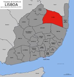
Olivais (Portuguese pronunciation: [oliˈvajʃ], before 2012: Santa Maria dos Olivais) is an urban civil parish in the municipality of Lisbon, Portugal. The population in 2011 was 33,788, in an area of 8.09 km². In 2012 part of the parish was joined to the new parish Parque das Nações.
Local landmarks include the Palácio do Contador-Mor, a pedagogic farm, Casa da Fonte do Anjo, Quinta da Bica, Quinta da Fonte do Anjo, Capela da Quinta da Fonte do Anjo.
The parish was created in 1397, probably resulting in the division of a part of Beato (to the south) and Sacavém (to the north). Between 1852 and 1886 Santa Maria dos Olivais formed a large municipality, predominantly rural, including 22 civil parishes.
In 1864 it occupied a surface of approximately 223 km2 and had a population of 25,495, and of 29,491, in 1878.
Companies with head offices in Santa Maria dos Olivais and Portela Airport include TAP Portugal.
With the 2012 administrative reform, the parish name was reduced from Santa Maria dos Olivais to Olivais.
...
Wikipedia

