Santa Maria di Leuca

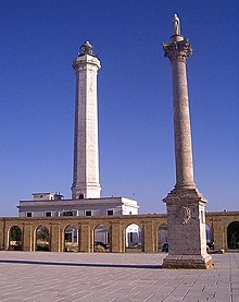
The lighthouse of Santa Maria di Leuca
|
|
|
Apulia
|
|
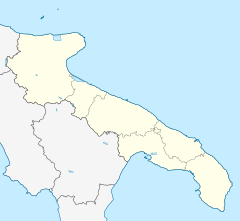
| Location | Santa Maria di Leuca Apulia Italy |
|---|---|
| Coordinates | 39°47′45.4″N 18°22′06.7″E / 39.795944°N 18.368528°E |
| Year first constructed | 1866 |
| Construction | brick tower |
| Tower shape | octagonal prism tower with balcony and lantern atop a 2-storey keeper’s house |
| Markings / pattern | white tower |
| Height | 48 metres (157 ft) |
| Focal height | 102 metres (335 ft) |
| Original lens | first order Fresnel Lens (removed 1954) |
| Current lens | type OR T6 |
| Light source | mains power |
| Range | main: 24 nautical miles (44 km; 28 mi) reserve: 10 nautical miles (19 km; 12 mi) |
| Characteristic | Fl (3) W 15s. Oc R 4s. (to east) |
| Admiralty number | E2176 |
| NGA number | 10780 |
| ARLHS number | ITA-039 |
| Italy number | 3590 E.F. |
| Managing agent | Marina Militare |
Santa Maria di Leuca, often spelled simply Leuca (Greek: Λευκά, from Leukos, "white"), is a frazione of the comune of Castrignano del Capo, in the province of Lecce (Apulia), southern Italy. A part of the town once belonged to the comune of Gagliano del Capo.
Santa Maria di Leuca is famous for its iconic lighthouse. With its height of 47 metres, and position at 102 metres above sea level, is the second most important lighthouse in Italy, after Genova. Next to the lighthouse is the large Sanctuary, or Basilica, De Finibus Terrae ("End of the Land", 1720-1755), built to commemorate the passage of St. Peter here during his travel to Italy. It is devoted to Saint Mary (from whom the town gets the name Santa Maria di Leuca). It lies on the former site of a Roman temple dedicated to Minerva. The edifice has a fortified structure, and during its existence it sustained several assault by Algerian pirates. In the same site, a Corinthian column was erected in 1939 to celebrate the construction of the Apulian Aqueduct (Acquedotto Pugliese). The basilica is connected to the port through a 284-step staircase.
Punta Meliso promontory (the ancient Promontorium lapygium or Sallentinum) is the southeastern extremity of Italy — traditionally considered the lowest point of the geographical "heel" of Italian peninsula, as well as the meeting point of the waters from the Adriatic Sea and the Ionian Sea. But Leuca is a bay so there's another promontory called Punta Ristola challenging this geographical particularity. According to Google Earth, Punta Ristola, at 39° 47′ 22.96″ N, is approximately 440 meters south of Punta Meliso, at 39° 47′ 37.73″ N.
After World War II the town hosted Jewish Holocaust survivors for two years (1946-1948), giving them warm hospitality.
...
Wikipedia

