Sanford, Colorado
| Town of Sanford, Colorado | |
|---|---|
| Town | |
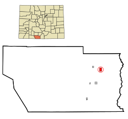
 Location in Conejos County and the state of Colorado |
|
| Coordinates: 37°15′27″N 105°54′2″W / 37.25750°N 105.90056°WCoordinates: 37°15′27″N 105°54′2″W / 37.25750°N 105.90056°W | |
| Country |
|
| State |
|
| County | Conejos County |
| Incorporated | April 9, 1907 |
| Government | |
| • Type | Statutory Town |
| Area | |
| • Total | 1.5 sq mi (3.8 km2) |
| • Land | 1.5 sq mi (3.8 km2) |
| • Water | 0 sq mi (0 km2) |
| Elevation | 7,605 ft (2,318 m) |
| Population (2010) | |
| • Total | 879 |
| • Density | 599/sq mi (231.3/km2) |
| Time zone | MST (UTC-7) |
| • Summer (DST) | MDT (UTC-6) |
| ZIP code | 81151 |
| Area code(s) | 719 |
| FIPS code | 08-67830 |
| GNIS feature ID | 0203638 |
| Website | www |
Sanford is a Statutory Town in Conejos County, Colorado, United States. The population was 879 at the 2010 census.
A post office called Sanford has been in operation since 1888. The town was named after Silas Sanford Smith, a Mormon pioneer.
Sanford is located in northeastern Conejos County at 37°15′27″N 105°54′2″W / 37.25750°N 105.90056°W (37.257437, -105.900591), in the San Luis Valley of southern Colorado. The town of La Jara is 3 miles (5 km) to the west by State Highway 136.
According to the United States Census Bureau, the town has a total area of 1.5 square miles (3.8 km2), all of it land.
As of the census of 2000, there were 817 people, 273 households, and 212 families residing in the town. The population density was 579.9 people per square mile (223.7/km²). There were 295 housing units at an average density of 209.4 per square mile (80.8/km²). The racial makeup of the town was 76.87% White, 0.12% African American, 0.73% Native American, 16.65% from other races, and 5.63% from two or more races. Hispanic or Latino of any race were 40.51% of the population.
...
Wikipedia
