Sanem
|
Sanem Suessem |
||
|---|---|---|
| Commune | ||

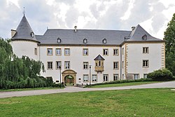
The castle
|
||
|
||
 Map of Luxembourg with Sanem highlighted in orange, and the canton in dark red |
||
| Coordinates: 49°32′50″N 5°55′40″E / 49.5472°N 5.9278°ECoordinates: 49°32′50″N 5°55′40″E / 49.5472°N 5.9278°E | ||
| Country |
|
|
| Canton | Esch-sur-Alzette | |
| Government | ||
| • Mayor | Georges Engel | |
| Area | ||
| • Total | 24.42 km2 (9.43 sq mi) | |
| Area rank | 35 of 105 | |
| Highest elevation | 422 m (1,385 ft) | |
| • Rank | 34th of 105 | |
| Lowest elevation | 277 m (909 ft) | |
| • Rank | 82nd of 105 | |
| Population (2014) | ||
| • Total | 15,047 | |
| • Rank | 6th of 105 | |
| • Density | 620/km2 (1,600/sq mi) | |
| • Density rank | 11th of 105 | |
| Time zone | CET (UTC+1) | |
| • Summer (DST) | CEST (UTC+2) | |
| LAU 2 | LU00010013 | |
| Website | sanem.lu | |
Sanem (Luxembourgish: Suessem, French: Sanem or German: Sassenheim) is a commune and town in south-western Luxembourg. It is part of the canton of Esch-sur-Alzette, which is part of the district of Luxembourg. The administrative centre and largest town is Belvaux.
As of 2005[update], the town of Sanem, which lies in the north of the commune, has a population of 2,397. Other towns within the commune include Belvaux, Ehlerange, and Soleuvre.
Sanem Castle has a history dating back to the 13th century. Today's building was completed in 1557 after the medieval castle had been partly destroyed. The castle still maintains much of its original character.
...
Wikipedia

