San Sebastián del Oeste
| San Sebastián del Oeste | |
|---|---|
| Municipality and city | |

San Sebastián del Oeste is nestled in a narrow mountain valley
|
|
| Nickname(s): El Real | |
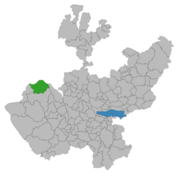
 Location of the municipality in Jalisco |
|
| Location in Mexico | |
| Coordinates: 20°45′40″N 104°51′08″W / 20.76114°N 104.852273°W | |
| Country |
|
| State | Jalisco |
| Area | |
| • Total | 1,400.13 km2 (540.59 sq mi) |
| Population (2005) | |
| • Total | 5,626 |
| Time zone | Central Standard Time (UTC-6) |
| • Summer (DST) | Central Daylight Time (UTC-5) |
San Sebastián del Oeste (Spanish ![]() ) is a town and municipality, located on the western part of Jalisco state, Mexico, between 20°39’45’’ - 21°02’30’’ N and 104°35’00’’ - 104°51’00’’ W, at a height of 1,480 metres (4,856 ft).
) is a town and municipality, located on the western part of Jalisco state, Mexico, between 20°39’45’’ - 21°02’30’’ N and 104°35’00’’ - 104°51’00’’ W, at a height of 1,480 metres (4,856 ft).
The municipality of San Sebastián del Oeste borders the state of Nayarit to the north; to the south, the municipality of Mascota; to the east, the municipalities of Guachinango and Mascota; and to the west, Puerto Vallarta.
The city and municipality are served by an airfield.
San Sebastián was founded as a mining town in 1605, during the early Spanish colonial Viceroyalty of New Spain period. Gold, silver and lead were mined in the area. More than 25 mines and a number of foundries were established by 1785.
The town was formally established as a city in 1812.
At the start of the 21st century, San Sebastián city has a population of less than 1,000 people.
It reached a peak population of around 20,000 people by 1900. The prosperity of the city declined after the revolution of 1910.
San Sebastián del Oeste is a designated Pueblos Mágicos, one of the towns maintaining their historical character and promoted by the federal government as tourism destinations. It also receives tourists visiting nearby Puerto Vallarta on the coast to the west. Recent road improvements reduced transit time from Puerto Vallarta to under 2 hours.
...
Wikipedia

