San Mateo Creek (Southern California)
| San Mateo Creek | |
| Arroyo de San Mateo, Rio San Mateo | |
| River | |
|
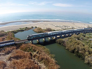
San Mateo Creek Lagoon at the mouth
|
|
| Country | United States |
|---|---|
| State | California |
| Regions | San Diego County, Riverside County |
| District | Marine Corps Base Camp Pendleton |
| Tributaries | |
| - left | Los Alamos Canyon Creek, Tenaja Canyon Creek, Devil Canyon Creek |
| - right | Bluewater Canyon Creek, Nickel Canyon Creek, Cristianitos Creek |
| Source | canyon on the west face of San Mateo Peak |
| - location | Elsinore Mountains, within the Santa Ana Mountains, Cleveland National Forest, Riverside County, California, United States |
| - elevation | 2,800 ft (853 m) |
| - coordinates | 33°37′12″N 117°23′17″W / 33.62000°N 117.38806°W |
| Mouth | San Mateo Creek (Southern California) |
| - location | Pacific Ocean, San Onofre State Beach, San Diego County |
| - elevation | 0 ft (0 m) |
| - coordinates | 33°23′05″N 117°35′34″W / 33.38472°N 117.59278°WCoordinates: 33°23′05″N 117°35′34″W / 33.38472°N 117.59278°W |
| Length | 22 mi (35 km) |
| Basin | 139 sq mi (360 km2) |
| Discharge | for San Clemente |
| - average | 12.1 cu ft/s (0 m3/s) |
| - max | 12,500 cu ft/s (354 m3/s) |
| - min | 0 cu ft/s (0 m3/s) |
|
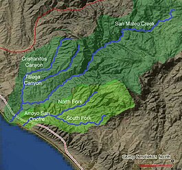
Map of San Mateo Creek and Arroyo San Onofre drainage basins. San Mateo Creek basin is in dark green.
|
|
San Mateo Creek is a stream in Southern California in the United States, whose watershed mostly straddles the border of Orange and San Diego Counties. It is about 22 miles (35 km) long, flowing in a generally southwesterly direction. Draining a broad valley bounded by the Santa Ana Mountains and Santa Margarita Mountains, San Mateo Creek is notable for being one of the last unchannelized streams in Southern California.
One of the least developed watersheds on the South Coast, San Mateo Creek's drainage basin covers 139 square miles (360 km2) in parts of the Cleveland National Forest and Marine Corps Base Camp Pendleton. The first inhabitants were Native Americans primarily of the Acjachemen and Luiseño groups, followed by the Spanish who established ranchos in the area. The creek's usually perennial flow made it an important source of irrigation water, then in the later 19th century, there was a gold rush in the upper watershed. Most of the little development in the watershed is now agriculture-based.
The San Mateo Creek watershed includes the subwatersheds of Los Alamos Canyon Creek, Tenaja Canyon Creek, Devil Canyon Creek and Cristianitos Creek with its tributaries of Talega and Gabino Creeks. Although grazing activities have hurt the biological quality of the semi-arid, Mediterranean-climate watershed, it still supports numerous biological communities including riparian zones, grassland and coastal sage scrub. A population of steelhead trout has recently been identified in the creek, which is affected by continuing groundwater pumping, and which may have been minimally impacted by minor agricultural runoff prior to cessation of farming activities along the stream aboard Marine Corps Base Camp Pendleton.
...
Wikipedia


