San Luis, Colorado
|
San Luis, Colorado San Luis de la Culebra |
|
|---|---|

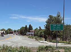
Entering San Luis from the west
|
|
| Motto: The Oldest Town in Colorado | |
 Location in Costilla County and the state of Colorado |
|
| Coordinates: 37°12′7″N 105°25′20″W / 37.20194°N 105.42222°WCoordinates: 37°12′7″N 105°25′20″W / 37.20194°N 105.42222°W | |
| Country |
|
| State |
|
| County | Costilla County - seat |
| Established | 1851-04-09 |
| Government | |
| • Type | Statutory Town |
| Area | |
| • Total | 0.5 sq mi (1.4 km2) |
| • Land | 0.5 sq mi (1.4 km2) |
| • Water | 0 sq mi (0 km2) |
| Elevation | 7,979 ft (2,432 m) |
| Population (2010) | |
| • Total | 629 |
| • Density | 1,124/sq mi (434.1/km2) |
| Time zone | MST (UTC-7) |
| • Summer (DST) | MDT (UTC-6) |
| ZIP code | 81152 |
| Area code(s) | 719 |
| FIPS code | 08-68105 |
| GNIS feature ID | 0204787 |
| Website | townofsanluisco |
|
|
|
The Town of San Luis is a statutory town that is the county seat and the most populous town of Costilla County, Colorado, United States. Formerly known as San Luis de la Culebra, San Luis is the oldest continuously occupied town in Colorado. The population was 629 at the 2010 census.
Hispanic settlers from the Taos Valley established several small villages along the Rio Culebra in the San Luis Valley and officially took possession of this portion of the Sangre de Cristo Land Grant on April 9, 1851. Settlers built a church in the central village of La Plaza Medio and dedicated it on the Feast of Saint Louis, June 21, 1851. The village was renamed San Luis de la Culebra in honor of its patron saint. San Luis remained part of the Territory of New Mexico until 1861 when the Territory of Colorado was established. Today, San Luis is the oldest continuously inhabited town in the state of Colorado.
The town of San Luis lies within the San Luis Valley at 37°12′7″N 105°25′20″W / 37.20194°N 105.42222°W (37.201988, -105.422360), south of the geographic center of Costilla County. Colorado State Highway 159 leads north 15 miles (24 km) to Fort Garland and U.S. Route 160, and south 18 miles (29 km) to the New Mexico border. Highway 142 leads west 31 miles (50 km) to Manassa.
...
Wikipedia
