San Juan Island National Historical Park
| National Historical Park | |
|---|---|
|
IUCN category V (protected landscape/seascape)
|
|

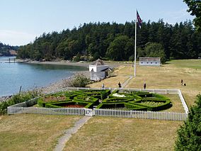
British Camp
|
|
| Location | San Juan County, Washington, USA |
| Nearest city | Friday Harbor, Washington |
| Coordinates | 48°27′21″N 122°59′08″W / 48.45583°N 122.98556°WCoordinates: 48°27′21″N 122°59′08″W / 48.45583°N 122.98556°W |
| Area | 2,072 acres (8.39 km2) |
| Authorized | September 9, 1966 |
| Visitors | 266,717 (in 2011) |
| Governing body | National Park Service |
| Website | San Juan Island National Historical Park |
| Designated | November 5, 1961 |
| Designated | October 15, 1966 |
San Juan Island National Historical Park, also known as American and English Camps, San Juan Island, is a U.S. National Historical Park owned and operated by the National Park Service on San Juan Island in the state of Washington. The park is made up of the sites of the British and U.S. Army camps during the Pig War, a boundary dispute over the ownership of the island. Both of these camps were set up in 1859 as response to a border controversy triggered by the killing of a pig. The camps were occupied for 12 years, until the islands were awarded to the United States by Kaiser Wilhelm I in an arbitration agreed by the parties in the 1872 Treaty of Washington. The British abandoned their camp in November 1872, while the American camp was disbanded in July 1874. The camp sites were designated a National Historic Landmark in 1961, and listed on the National Register of Historic Places in 1966. The park was created by an Act of Congress in 1966.
San Juan Island is located in Puget Sound, the westernmost of the main islands of the San Juan Islands group. This island group is separated from Vancouver Island (part of British Columbia in Canada) by the Haro Strait, and from the Washington mainland by the Rosario Strait. These two channels defined the competing territorial claims of the United States and Great Britain after the Oregon Treaty of 1846 settled most of the northwestern border.
...
Wikipedia


