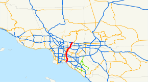
San Gabriel River Freeway
| Interstate 605 | ||||
|---|---|---|---|---|
| San Gabriel River Freeway | ||||

I-605 highlighted in red
|
||||
| Route information | ||||
| Defined by | ||||
| Maintained by Caltrans | ||||
| Length: | 27.40 mi (44.10 km) | |||
| History: | 1940s as a state highway, 1964 as a number | |||
| Major junctions | ||||
| South end: |
|
|||
|
||||
| North end: |
|
|||
| Location | ||||
| Counties: | Los Angeles | |||
| Highway system | ||||
|
||||
Interstate 605 (abbreviated I-605, officially known as the San Gabriel River Freeway) is a major north–south Interstate Highway in the Greater Los Angeles Area of Southern California. It is about 27 miles (43 km) in length, and runs from Seal Beach to Irwindale, closely paralleling the San Gabriel River for most of its alignment. The San Gabriel River Freeway is one of the few Southern California freeways not named after a city along its route.
This route is part of the California Freeway and Expressway System.
The California Streets and Highways Code defines Route 605 as "(a) Route 1 near Seal Beach to Route 405. (b) Route 405 to Route 210 near Duarte." However, the portion in subsection A has yet to be constructed.
The southern terminus of I-605 is at the San Diego (I-405) and Garden Grove (State Route 22) Freeways in Seal Beach. From there, it runs roughly north through the Gateway Cities of the Los Angeles Basin. It then shifts north-northeast, crossing the Whittier Narrows and across the San Gabriel Valley. I-605 then ends at its junction with the Foothill Freeway, (I-210) in Duarte, a small city located at the foothills of the San Gabriel Mountains.
...
Wikipedia

