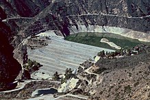
San Gabriel Reservoir
| San Gabriel Dam | |
|---|---|

The dam seen from Glendora Mountain Road
|
|
| Country | United States |
| Location | Los Angeles County, California |
| Coordinates | 34°12′20″N 117°51′33″W / 34.20556°N 117.85917°WCoordinates: 34°12′20″N 117°51′33″W / 34.20556°N 117.85917°W |
| Construction began | 1932 |
| Opening date | 1939 |
| Construction cost | $17 million |
| Owner(s) | Los Angeles County Flood Control District |
| Dam and spillways | |
| Type of dam | Rock-fill |
| Impounds | San Gabriel River |
| Height | 315 ft (96 m) |
| Length | 1,520 ft (460 m) |
| Spillway type | Ungated overflow |
| Reservoir | |
| Creates | San Gabriel Reservoir |
| Total capacity | 44,183 acre·ft (54,499 dam3) |
| Catchment area | 205 sq mi (530 km2) |
| Surface area | 525 acres (212 ha) |
| Power Station | |
| Operator(s) | City of Azusa |
| Commission date | 1940 |
| Installed capacity | 3 MW |
| Annual generation | 4,464,000 KWh |
San Gabriel Dam is a rock-fill dam on the San Gabriel River in Los Angeles County, California, within the Angeles National Forest. Completed in 1939, the dam impounds the main stem of the San Gabriel River about 2.5 miles (4.0 km) downstream from the confluence of the river's East and West Forks, which drain a large portion of the San Gabriel Mountains. The dam provides flood control, groundwater recharge flows and hydroelectricity for the heavily populated San Gabriel Valley in the Greater Los Angeles metropolitan area.
In the 1920s, the Los Angeles County Flood Control District proposed to impound the San Gabriel River just below the confluence of the East and West forks with a 512-foot (156 m) high, 2,500-foot (760 m) long concrete arch dam to capture floods and provide water conservation. To be named the San Gabriel Forks Dam, the project was canceled by the State Engineer after having convened an inquiry to investigate problems which were occurring at San Gabriel Dam site, including a landslide that destroyed a large portion of the construction site, in early November 1929. The inquiry panel concluded and issued a report to the State Engineer stating that the proposed dam "cannot be constructed without creating a menace to life and property."
Subsequently, the design of the San Gabriel River flood control project was changed from one large dam to two smaller dams: San Gabriel No. 1 (San Gabriel Dam), about 2 miles (3.2 km) below the original Forks site, and San Gabriel No. 2 (Cogswell Dam), on the West Fork about 15 miles (24 km) above the confluence. The cost of San Gabriel No. 1 was greatly understated, creating a scandal; in context with the Great Depression, the Los Angeles Times observed that "it is not now necessary to gamble $26 million on a [troubled and wasteful agency]". The bond measure necessary for financing of the project was defeated by a narrow margin of 52 to 48 percent. As a result, the city turned to the federal Public Works Administration for money to complete the project.
...
Wikipedia
