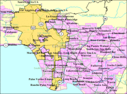
Los Angeles metropolitan area
| Los Angeles Metropolitan Area | |
|---|---|
| Los Angeles–Long Beach–Anaheim | |
 |
|
| Coordinates: 33°54′N 118°15′W / 33.9°N 118.25°W | |
| Country | United States |
| State(s) | California |
| Largest city | Los Angeles |
| Other cities | – Long Beach – Anaheim – Santa Ana – Irvine – Glendale – Huntington Beach – Santa Clarita |
| Area | |
| • Total | 4,850.3 sq mi (12,562 km2) |
| Highest elevation | Mount San Antonio 10,068 ft (3,069 m) |
| Lowest elevation | Wilmington −9 ft (-3 m) |
| Population (2010) | |
| • Total | 12,828,837 |
| • Rank | 2nd in the U.S. |
| • Density | 2,645.0/sq mi (1,024.7/km2) |
Coordinates: 34°N 118°W / 34°N 118°W
The Los Angeles metropolitan area, also known as Metropolitan Los Angeles or the Southland, is the 18th largest metropolitan area in the world and the second-largest metropolitan area in the United States. It is entirely located in the southern portion of the U.S. State of California.
The metropolitan area is defined by the Office of Management and Budget as the Los Angeles-Long Beach-Anaheim, CA Metropolitan Statistical Area (MSA), consisting of Los Angeles and Orange counties, a metropolitan statistical area used for statistical purposes by the United States Census Bureau and other agencies. Its land area is 4,850 sq. mi (12,562 km2).
Los Angeles and Orange counties are the first and third most populous counties in California respectively, and Los Angeles, with 9,819,000 people in 2010, is the most populous county in the United States. The combined Los Angeles metropolitan area is home to 18.2 million people, making it the most populous metropolitan area in the western United States and the largest in area in the United States. The metro area has at its core the Los Angeles-Long Beach-Anaheim corridor, an urbanized area defined by the Census Bureau with a population 12,150,996 as of the 2010 Census.
...
Wikipedia
