San Fernando City Corporation
| The City of San Fernando | |||||||
|---|---|---|---|---|---|---|---|
| City Corporation | |||||||
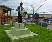
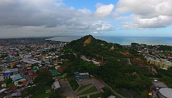
From top (left to right) University of Trinidad and Tobago, Panorama of San Fernando, Steelpan Monument, High Street, San Fernando Hill
|
|||||||
| Nickname(s): Sando | |||||||
| Motto: Sanitas Fortis In a Healthy Environment We Will Find Strength. |
|||||||
 |
|||||||
| Coordinates: 10°17′N 61°28′W / 10.283°N 61.467°WCoordinates: 10°17′N 61°28′W / 10.283°N 61.467°W | |||||||
| Country |
|
||||||
| Jurisdiction | City of San Fernando | ||||||
| Named for | Saint Ferdinand III of Castile | ||||||
| Government | |||||||
| • Mayor | Junia Regrello | ||||||
| Area | |||||||
| • Total | 18.64 km2 (7.20 sq mi) | ||||||
| Population (2011) | |||||||
| • Total | 48,838 | ||||||
| • Density | 2,970/km2 (7,700/sq mi) | ||||||
| ranked 3rd | |||||||
| Time zone | AST (UTC-4) | ||||||
| Website | sancity |
||||||
San Fernando, officially the City Corporation of San Fernando, is the most populous city in Trinidad and Tobago. It occupies 18 km² and is located in the southwestern part of the island of Trinidad. It is bounded to the north by the Guaracara River, the south by the Oropouche River, the east by the Sir Solomon Hochoy Highway, and the west by the Gulf of Paria. The former borough was elevated to the status of a city corporation on November 18, 1988. The motto of San Fernando is: "Sanitas Fortis" - In a Healthy Environment We Will Find Strength. Many local Trinidadians refer to the city with the shortened name "Sando." San Fernando is called Trinidad and Tobago's "industrial capital" because of its proximity to the Pointe-a-Pierre oil refinery and many other petrochemical, LNG, iron and steel and aluminium smelters in places such as Point Lisas, Point Fortin, and La Brea.
The Amerindians called the area Anaparima, which has been translated as either "single hill" or "without water". A single hill, San Fernando Hill, rises from the centre of the city. A town named San Fernando de Naparima was established by Spanish Governor Don José Maria Chacón in 1784, in honour of the heir to Spanish crown. With time, the "de Naparima" was dropped.
Following the 1783 Cedula of Population, many sugarcane plantations were established in the Naparima Plains surrounding San Fernando. The town grew as this part of the country came to dominate sugar production. This growth continued throughout the nineteenth century as consolidation in the sugar industry led to the construction of what was then the largest sugar refinery in the world, the Usine, Ste. Madeline factory a few miles east of the town. The development of cacao cultivation and the petroleum industry helped San Fernando grow since the town served as the gateway to these areas.
...
Wikipedia


