Samnaun
| Samnaun | ||
|---|---|---|
 |
||
|
||
| Coordinates: 46°56′N 10°21′E / 46.933°N 10.350°ECoordinates: 46°56′N 10°21′E / 46.933°N 10.350°E | ||
| Country | Switzerland | |
| Canton | Grisons | |
| District | Engiadina Bassa/Val Müstair | |
| Area | ||
| • Total | 56.31 km2 (21.74 sq mi) | |
| Elevation (Church) | 1,844 m (6,050 ft) | |
| Population (Dec 2015) | ||
| • Total | 773 | |
| • Density | 14/km2 (36/sq mi) | |
| Postal code | 7562-63 | |
| SFOS number | 3752 | |
| Localities | Compatsch, Laret, Plan, Ravaisch and Samnaun | |
| Surrounded by | Ischgl (AT-7), Kappl (AT-7), Ramosch, See (AT-7), Spiss (AT-7), Valsot | |
| Website |
www SFSO statistics |
|
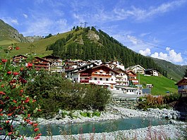
Samnaun (Romansh: Samignun) is a high Alpine village and a valley at the eastern end of Switzerland and a municipality in the Engiadina Bassa/Val Müstair Region in the Swiss canton of Graubünden.
The valley was first used as a seasonal mountain pasture for the villages of Tschlin and Ramosch. By 1220 the first permanent farm houses are mentioned. These farm houses and fields were given as a gift to the Marienberg Abbey by the counts of Tarasp in the 12th century.
As of 2006[update] Samnaun has an area of 56.2 km2 (21.7 sq mi). Of this area, 46.1% is used for agricultural purposes, while 11.7% is forested. Of the rest of the land, 0.9% is settled (buildings or roads) and the remainder (41.2%) is non-productive (rivers, glaciers or mountains).
Until 2017 it was part of the Ramosch sub-district, of the Inn district, after 2017 it was part of the Engiadina Bassa/Val Müstair Region. It is located in a left side valley of the Engadin valley, at an elevation of 1,700–1,840 meters (5,580–6,040 ft). It consists of five village sections; Compatsch, Laret, Plan (Plaun), Ravaisch and Samnaun.
In the 19th century, Samnaun could only be reached by road from Spiss in Austria. Thus Samnaun was excluded from the Swiss customs territory. It retains a privileged 'duty-free' status, albeit not without controversy, in the twenty-first century. The exception was maintained even after a road was built in 1905 linking Samnaun to Martina, at the most eastern point of the Lower Engadine.
...
Wikipedia


