Salvatierra, Guanajuato
|
San Andrés de Salvatierra Ciudad de Salvatierra |
|
|---|---|

View of the Tetilla hills
|
|
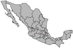
 Location of Salvatierra in Mexico |
|
| Coordinates: 20°12′56″N 100°53′46″W / 20.21556°N 100.89611°WCoordinates: 20°12′56″N 100°53′46″W / 20.21556°N 100.89611°W | |
| Country |
|
| Founded (officially) | 1644 (By Garcia Sarmiento de Sotomayor) |
| Government | |
| • Municipal president | Rito Vargas (PAN) |
| Elevation | 1,749 m (5,738 ft) |
| Population (2000) | |
| • Total | 34,066 city; 94,558 municipality |
| Time zone | Central Standard Time (UTC-6) |
| • Summer (DST) | Central Daylight Time (UTC-5) |
| Website | Official Website of the City of Salvatierra |
| Average temperature 18°C | |
Salvatierra (Spanish ![]() ) is a Mexican city (and municipality) located in the valley of Huatzindeo in the lowlands of the state of Guanajuato. With an area of 507.70 square kilometres, Salvatierra accounts for 1.66% the total area of the state. It is bordered to the north by Tarimoro and Cortazar, to the south by Acámbaro and the state of Michoacán, to the west by Yuriria and Santiago Maravatío, and to the northeast by Jaral del Progreso. The municipality had a total of 94,558 inhabitants of which 34,066 lived in the city of Salvatierra, according to the 2005 census.
) is a Mexican city (and municipality) located in the valley of Huatzindeo in the lowlands of the state of Guanajuato. With an area of 507.70 square kilometres, Salvatierra accounts for 1.66% the total area of the state. It is bordered to the north by Tarimoro and Cortazar, to the south by Acámbaro and the state of Michoacán, to the west by Yuriria and Santiago Maravatío, and to the northeast by Jaral del Progreso. The municipality had a total of 94,558 inhabitants of which 34,066 lived in the city of Salvatierra, according to the 2005 census.
In pre-Columbian times the area was known as Guatzindeo or "Place of beautiful vegetation" by the mostly Purépecha inhabitants.
The first inhabitants of valley of Huatzindeo belonged to the Chichimeca culture, who by the 12th century were found in many communities across the valley. The Chichimeca were eventually conquered by the Purépecha people, along with most of the lower region of the present-day state of Guanajuato.
...
Wikipedia
