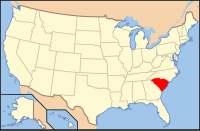
Saluda County, South Carolina
| Saluda County, South Carolina | |
|---|---|
 Location in the U.S. state of South Carolina |
|
 South Carolina's location in the U.S. |
|
| Founded | 1896 |
| Named for | Saluda River |
| Seat | Saluda |
| Largest town | Saluda |
| Area | |
| • Total | 462 sq mi (1,197 km2) |
| • Land | 453 sq mi (1,173 km2) |
| • Water | 9.0 sq mi (23 km2), 2.0% |
| Population | |
| • (2010) | 19,875 |
| • Density | 44/sq mi (17/km²) |
| Congressional district | 3rd |
| Time zone | Eastern: UTC-5/-4 |
| Website | www |
Saluda County is a county located in the U.S. state of South Carolina. As of the 2010 census, the population was 19,875. Its county seat is Saluda. The county was formed from northern and eastern portions of Edgefield County.
Saluda County is part of the Augusta-Richmond County, GA-SC Metropolitan Statistical Area.
According to the U.S. Census Bureau, the county has a total area of 462 square miles (1,200 km2), of which 453 square miles (1,170 km2) is land and 9.0 square miles (23 km2) (2.0%) is water. Saluda County is largely in the Saluda River basin with a small portion of western Saluda in the Savannah River basin.
As of the census of 2000, there were 19,181 people, 7,127 households, and 5,295 families residing in the county. The population density was 42 people per square mile (16/km²). There were 8,543 housing units at an average density of 19 per square mile (7/km²). The racial makeup of the county was 65.80% White, 29.99% Black or African American, 0.23% Native American, 0.04% Asian, 0.01% Pacific Islander, 3.29% from other races, and 0.64% from two or more races. 7.30% of the population were Hispanic or Latino of any race.
...
Wikipedia
