Salton Sink
| Salton Sink | |
| physiographic section | |
|
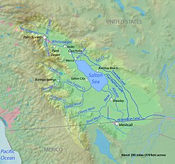
The Salton Sink is part of the Salton Watershed (light green area).
|
|
| Country | United States |
|---|---|
| State | California |
| Part of | Basin and Range Province |
| Parts | Coachella Valley, Imperial Valley |
| Coordinates | 33°20′00″N 115°50′03″W / 33.3334°N 115.8342°WCoordinates: 33°20′00″N 115°50′03″W / 33.3334°N 115.8342°W |
| Biome | Sonoran Desert ecoregion |
The Salton Sink is a geographic sink within the Salton Trough in the Coachella and Imperial valleys of southeastern California. It is in the Colorado Desert subregion of the Sonoran Desert ecoregion. Drainage to the endorheic sink collects in the Salton Sea, which occupies the lowest area of the sink.
The Salton Sink is the topographic low area within the Salton Trough, an active tectonic pull-apart basin. The Salton Trough is a result of crustal stretching and sinking by the combined actions of the San Andreas Fault and the East Pacific Rise. The Brawley seismic zone forms the southeast end of the basin and connects the San Andreas Fault system with the Imperial Fault Zone to the south. The Salton Buttes are rhyolite lava domes within the basin which were active 10,300 (± 1000) years BP.
A large lake, Lake Cahuilla, existed in the area from about 20,500 to 3,000 years ago and left evidence as wave cut benches on the higher portions of the Salton Buttes. A beach mark outlines the shoreline of ancient Lake Cahuilla where archeologists found rock fish traps and charred remains of razorback sucker and bonytail bones. High water lines suggest the basin has filled many times, creating a lake some 105 miles (170 km) in length and nearly 300 feet (100 m) deep. Its most recent incarnation is evidenced by fish traps found some 30 feet (10 m) below the high-water mark that were estimated to be between 300 and 1,000 years old.
...
Wikipedia

