Salesville, Arkansas
| Salesville, Arkansas | |
|---|---|
| City | |
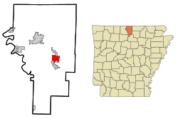
 Location in Baxter County and the state of Arkansas |
|
| Coordinates: 36°14′41″N 92°16′32″W / 36.24472°N 92.27556°WCoordinates: 36°14′41″N 92°16′32″W / 36.24472°N 92.27556°W | |
| Country | United States |
| State | Arkansas |
| County | Baxter |
| Area | |
| • Total | 4.5 sq mi (11.6 km2) |
| • Land | 4.5 sq mi (11.6 km2) |
| • Water | 0 sq mi (0 km2) |
| Elevation | 676 ft (206 m) |
| Population (2010) | |
| • Total | 450 |
| • Density | 101/sq mi (38.9/km2) |
| Time zone | Central (CST) (UTC-6) |
| • Summer (DST) | CDT (UTC-5) |
| ZIP code | 72653 |
| Area code(s) | 870 |
| FIPS code | 05-62240 |
| GNIS feature ID | 0076870 |
Salesville is a city in Baxter County, Arkansas, United States. The population was 450 in 2010.
Salesville is located in central Baxter County at 36°14′41″N 92°16′32″W / 36.24472°N 92.27556°W (36.244845, -92.275619). The center of town is at the intersection of Arkansas Highway 5 and 177, 1.5 miles (2.4 km) west of Norfork Dam. The North Fork River, after coming out of the dam, forms the eastern boundary of Salesville. Arkansas Highway 5 leads northwest 10 miles (16 km) to Mountain Home, the county seat, and south 3 miles (5 km) to the city of Norfork and 38 miles (61 km) to Mountain View.
According to the United States Census Bureau, the city has a total area of 4.5 square miles (11.6 km2), all of it land.
Salesville is in the Norfork School District with students graduating from Norfork High School.
As of the census of 2000, there were 437 people, 206 households, and 131 families residing in the city. The population density was 97.7 people per square mile (37.7/km²). There were 267 housing units at an average density of 59.7/sq mi (23.1/km²). The racial makeup of the city was 95.42% White, 1.37% Native American, 0.23% Asian, 0.69% from other races, and 2.29% from two or more races. 1.60% of the population were Hispanic or Latino of any race.
...
Wikipedia
