Mountain Home, Arkansas
| Mountain Home, Arkansas | |
|---|---|
| City | |
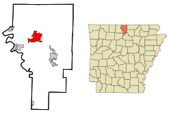
 Location in Baxter County and the state of Arkansas |
|
| Coordinates: 36°20′10″N 92°22′56″W / 36.33611°N 92.38222°WCoordinates: 36°20′10″N 92°22′56″W / 36.33611°N 92.38222°W | |
| Country | United States |
| State | Arkansas |
| County | Baxter |
| Area | |
| • Total | 11.7 sq mi (30.4 km2) |
| • Land | 11.7 sq mi (30.4 km2) |
| • Water | 0 sq mi (0 km2) |
| Elevation | 817 ft (249 m) |
| Population (2010) | |
| • Total | 12,448 |
| • Density | 1,187.9/sq mi (409.8/km2) |
| Time zone | Central (CST) (UTC-6) |
| • Summer (DST) | CDT (UTC-5) |
| ZIP codes | 72653-72654 |
| Area code(s) | 870 |
| FIPS code | 05-47390 |
| GNIS feature ID | 0077766 |
| Website | cityofmountainhome |
Mountain Home is a small city in and the county seat of Baxter County, Arkansas, United States, in the southern Ozark Mountains near the northern state border with Missouri. As of the 2010 census, the city had a population of 12,448. A total of 41,307 persons lived within the city and micropolitan combined, which encompasses the majority of Baxter County.
Mountain Home is located in northern Arkansas at 36°20′10″N 92°22′56″W / 36.33611°N 92.38222°W (36.336248, -92.382279). It is the center of the Twin Lakes area, with Norfork Lake 15 minutes to the east and Bull Shoals Lake 20 minutes to the northwest. It is located within the Ozarks mountain range, in the Salem Plateau region.
The city is located within 15 to 20 minutes of three rivers, the Buffalo National River, the White River and the North Fork River, which features the world-renowned Norfork Tailwater. These make the Mountain Home area one of the nation's top freshwater fishing destinations. Some creeks in the area with fishing access are Fall Creek, Dodd Creek, and Hicks Creek, with Fall Creek being the largest.
According to the United States Census Bureau, the city has a total area of 11.7 square miles (30.4 km2), all of it land.
...
Wikipedia
