Sainte-Thérèse-de-Gaspé, Quebec
| Sainte-Thérèse-de-Gaspé | |
|---|---|
| Municipality | |
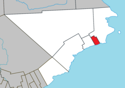
 Location within Le Rocher-Percé RCM. |
|
| Location in eastern Quebec. | |
| Coordinates: 48°25′N 64°25′W / 48.417°N 64.417°WCoordinates: 48°25′N 64°25′W / 48.417°N 64.417°W | |
| Country |
|
| Province |
|
| Region | Gaspésie–Îles-de-la-Madeleine |
| RCM | Le Rocher-Percé |
| Constituted | September 6, 1930 |
| Government | |
| • Mayor | Roberto Blondin |
| • Federal riding | Gaspésie—Îles-de-la-Madeleine |
| • Prov. riding | Gaspé |
| Area | |
| • Total | 34.60 km2 (13.36 sq mi) |
| • Land | 33.50 km2 (12.93 sq mi) |
| Population (2011) | |
| • Total | 1,055 |
| • Density | 31.5/km2 (82/sq mi) |
| • Pop 2006-2011 |
|
| • Dwellings | 470 |
| Time zone | EST (UTC−5) |
| • Summer (DST) | EDT (UTC−4) |
| Postal code(s) | G0C 3B0 |
| Area code(s) | 418 and 581 |
| Highways |
|
Sainte-Thérèse-de-Gaspé is a municipality in the Gaspésie-Îles-de-la-Madeleine region of the province of Quebec in Canada. It is the smallest municipality, in land area and population, of the Le Rocher-Percé Regional County Municipality.
Fishing is its primary business, and its harbour handles the fourth highest value of seafood in Quebec. Its factories, employing hundreds of people, process snow crab, rock crab, and lobster.
In addition to the village of Sainte-Thérèse-de-Gaspé itself, the municipality also includes the community of Saint-Isidore.
...
Wikipedia

