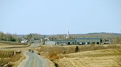
Sainte-Germaine-Boulé, Quebec
| Sainte-Germaine-Boulé | |
|---|---|
| Municipality | |
 |
|
 Location within Abitibi-Ouest RCM. |
|
| Location in western Quebec. | |
| Coordinates: 48°36′N 79°07′W / 48.600°N 79.117°WCoordinates: 48°36′N 79°07′W / 48.600°N 79.117°W | |
| Country |
|
| Province |
|
| Region | Abitibi-Témiscamingue |
| RCM | Abitibi-Ouest |
| Settled | 1932 |
| Constituted | January 1, 1954 |
| Government | |
| • Mayor | Jaclin Bégin |
| • Federal riding | Abitibi—Témiscamingue |
| • Prov. riding | Abitibi-Ouest |
| Area | |
| • Total | 110.60 km2 (42.70 sq mi) |
| • Land | 110.31 km2 (42.59 sq mi) |
| Population (2011) | |
| • Total | 895 |
| • Density | 8.1/km2 (21/sq mi) |
| • Pop 2006-2011 |
|
| • Dwellings | 375 |
| Time zone | EST (UTC−5) |
| • Summer (DST) | EDT (UTC−4) |
| Postal code(s) | J0Z 1M0 |
| Area code(s) | 819 |
| Highways |
|
| Website | www |
Sainte-Germaine-Boulé is a municipality in northwestern Quebec, Canada, in the Abitibi-Ouest Regional County Municipality. It covers 108.46 square kilometres (41.88 sq mi) and had a population of 895 as of the Canada 2011 Census.
The municipality was incorporated on January 1, 1954.
Population trend:
Private dwellings occupied by usual residents: 373 (total dwellings: 375)
Mother tongue:
...
Wikipedia

