Saint Heliers, New Zealand
| Saint Heliers | |
|---|---|

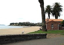
View of St Heliers Beach towards Achilles Point
|
|
 |
|
| Basic information | |
| Local authority | Auckland Council |
| Electoral ward | Orākei |
| Population | 4824 (2013) |
| Surrounds | |
| North | Hauraki Gulf, Rangitoto Island |
| Northeast | Browns Island |
| East | Bucklands Beach |
| Southeast | Glendowie |
| South | Glen Innes |
| Southwest | Saint Johns |
| West | Kohimarama, Mission Bay |
| Northwest | Orākei |
Saint Heliers is a seaside suburb of Auckland with a population of 4824. This suburb is popular amongst visitors for the beaches, cafés, and views of Rangitoto Island, the distinctive volcanic island in the Hauraki Gulf.
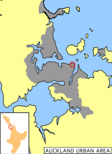
St. Heliers is located at the eastern end of Tamaki Drive, and used to be the place where the Tamaki estuary formally divided Auckland from Manukau City, until the entire Auckland region was amalgated under a single city authority, the Auckland Council, in 2010. Local government of St. Heliers is the responsibility of the Orakei Local Board, which also covers the suburbs of Orākei, Kohimarama, Mission Bay, Glendowie, St Johns, Meadowbank, Remuera and Ellerslie.
European settlement began on the north-facing slopes of St. Heliers bay, with the establishment of the Glen Orchard homestead, believed to have been built in the 1850s. The building was recognised as a place of historic, architectural and social significance by Heritage New Zealand in October 2010. This Regency-style residence incorporates Italianate influences, and has a grand and elegant appearance. Glen Orchard is a historic example of a prosperous rural homestead, and is linked to the settlers who comprised Auckland’s early elite. It is known as the residence of Lieutenant-General William Taylor (1790-1868), and his son Charles John Taylor who married into the family of the fourth New Zealand Premier, Alfred Domett. William Taylor was a retired senior officer of the East India Company’s Madras Army.
...
Wikipedia
