Saint-Eugène, Quebec
| Saint-Eugène | |
|---|---|
| Municipality | |
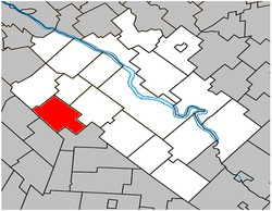
 Location within Drummond RCM. |
|
| Location in southern Quebec. | |
| Coordinates: 45°48′N 72°42′W / 45.800°N 72.700°WCoordinates: 45°48′N 72°42′W / 45.800°N 72.700°W | |
| Country |
|
| Province |
|
| Region | Centre-du-Québec |
| RCM | Drummond |
| Constituted | October 31, 1879 |
| Government | |
| • Mayor | Gilles Watier |
| • Federal riding | Drummond |
| • Prov. riding | Johnson |
| Area | |
| • Total | 76.20 km2 (29.42 sq mi) |
| • Land | 75.67 km2 (29.22 sq mi) |
| Population (2011) | |
| • Total | 1,131 |
| • Density | 14.9/km2 (39/sq mi) |
| • Pop 2006-2011 |
|
| • Dwellings | 502 |
| Time zone | EST (UTC−5) |
| • Summer (DST) | EDT (UTC−4) |
| Postal code(s) | J0C 1J0 |
| Area code(s) | 819 |
| Highways |
|
| Website | www |
Saint-Eugène is a municipality in the Centre-du-Québec region of Quebec. The population as of the Canada 2011 Census was 1,131.
Population trend:
Mother tongue language (2006)
...
Wikipedia

