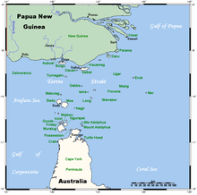
Saibai Island, Torres Strait

Landsat image of Saibai Island
|
|

A map of the Torres Strait Islands showing Saibai in the north central waters of Torres Strait
|
|
| Geography | |
|---|---|
| Coordinates | 9°24′S 142°41′E / 9.400°S 142.683°ECoordinates: 9°24′S 142°41′E / 9.400°S 142.683°E |
| Archipelago | Torres Strait Islands |
| Adjacent bodies of water | Torres Strait |
| Major islands | Saibai, Kauamag |
| Area | 107.9 km2 (41.7 sq mi) |
| Length | 21.8 km (13.55 mi) |
| Width | 5.2 km (3.23 mi) |
| Highest elevation | 1.7 m (5.6 ft) |
| Highest point | unnamed |
| Administration | |
|
Australia
|
|
| State | Queensland |
| Local government area | Shire of Torres |
| Island Region | Top Western |
| Largest settlement | Saibai (pop. 171) |
| Demographics | |
| Population | 465 (2016 census) |
| Pop. density | 4.3 /km2 (11.1 /sq mi) |
| Ethnic groups | Torres Strait Islanders |
Saibai Island is an island of the Torres Strait Islands archipelago, located in the Torres Strait of Queensland, Australia. The island is situated north of the Australian mainland and south of the island of New Guinea.
Most of the island is held under native title, apart from some government infrastructure and historic buildings.
The island was formed by alluvial deposits from Papua New Guinean rivers.
Saibai Island is a fairly large low-lying island located 8 kilometres (5.0 mi) south of the Papua New Guinea mainland. Close to the north of Saibai is the uninhabited Kauamag Island, separated from Saibai by a channel that is 7 kilometres (4.3 mi) long, between 180 and 650 metres (590 and 2,130 ft) wide, and nearly blocked at its east end.
The island is about 21.8 kilometres (13.5 mi) in length by 5.2 kilometres (3.2 mi) in width, and is flat, predominantly mangrove swamplands, with the highest point being 1.7 metres (5 ft 7 in) above mean sea level, and prone to flooding during the wet season, which coincides with king tides. A bitumen airstrip allows year-round access.
Saibai is part of the north-western island group of Torres Strait, which consists of Saibai, Dauan and Boigu islands. Saibai lies approximately 5 km off the coast of New Guinea and is approximately 20 km long and 6 km wide. The island is an average of 1 m above sea level and consists largely of mangrove fringe, flood plain and brackish swamps. The island is vulnerable to flooding and rising sea levels, particularly during the wet season when around 2 m of water regularly falls onto the island. During the dry season however, the island experiences drought-like conditions.
The main village of Saibai, in the northwest, has a population of 171. The second village, Churum [Surum White Sand], in the southwest, numbers 128.
Only a small proportion of the island is inhabited. In the 2016 Census, there were 465 people in Saibai Island. 84.0% of people were born in Australia. Torres Strait Islander and Aboriginal people made up 85.6% of the population, with 70% of the population claiming Torres Strait Islander ancestry. The most common response for religion was Anglican at 44.9%.
...
Wikipedia
