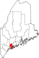
Sagadahoc County, ME
| Sagadahoc County, Maine | ||
|---|---|---|

|
||
|
||
 Location in the U.S. state of Maine |
||
 Maine's location in the U.S. |
||
| Founded | February 14, 1854 | |
| Named for | Indian word meaning "mouth of the big river" | |
| Seat | Bath | |
| Largest city | Bath | |
| Area | ||
| • Total | 370 sq mi (958 km2) | |
| • Land | 254 sq mi (658 km2) | |
| • Water | 116 sq mi (300 km2), 31% | |
| Population (est.) | ||
| • (2016) | 35,273 | |
| • Density | 139/sq mi (54/km²) | |
| Congressional district | 1st | |
| Time zone | Eastern: UTC-5/-4 | |
| Website | www |
|
Sagadahoc County (/ˈsæɡədəˌhɒk/ SAG-ə-də-hok) is a county located in the U.S. state of Maine. As of the 2010 census, the population was 35,293. Its county seat is Bath. In geographic area, it is the smallest county in Maine.
Sagadahoc County is part of the Portland–South Portland, ME Metropolitan Statistical Area.
Sagadahoc County was initially part of York and, later, Lincoln County before being set off and incorporated in 1854. The name comes from the "Sagadahoc River", an early name for the Kennebec River.Samuel de Champlain led the first known visit of Europeans to the region. In 1607, the English Popham Colony was established in what is now Phippsburgh; it was abandoned a year later, but English fishermen and trappers continued to visit the area. John Smith explored the region in 1614 and reported back to King Charles I, who named the Sagadahoc area "Leethe."
...
Wikipedia

