Sagada
| Sagada | ||
|---|---|---|
| Municipality | ||

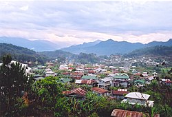
A view over the municipality of Sagada
|
||
|
||
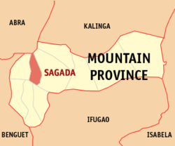
 Map of Mountain Province showing the location of Sagada |
||
| Location within the Philippines | ||
| Coordinates: 17°05′N 120°54′E / 17.083°N 120.900°ECoordinates: 17°05′N 120°54′E / 17.083°N 120.900°E | ||
| Country | Philippines | |
| Region | Cordillera Administrative Region (CAR) | |
| Province | Mountain Province | |
| District | Lone District | |
| Barangays | 19 | |
| Government | ||
| • Mayor | Eduardo T. Latawan Jr. | |
| Area | ||
| • Total | 83.32 km2 (32.17 sq mi) | |
| Population (2010) | ||
| • Total | 11,244 | |
| • Density | 130/km2 (350/sq mi) | |
| Time zone | PST (UTC+8) | |
| ZIP code | 2619 | |
| Dialing code | +63 (0)74 | |
| Income class | 5th class | |
| Website | sagada |
|
Sagada (Ilocano: Ili ti Sagada) is a fifth class municipality in the province of Mountain Province, Philippines. According to the 2010 census, it has a population of 11,244 people.
It is adjacent to , the provincial capital.
Sagada is famous for its hanging coffins. This is a traditional way of burying people that is still utilized. Not everyone is qualified to be buried this way; among other things, one had to have been married and had grandchildren.
Popular activities include trekking, exploring both caves and waterfalls, spelunking, bonfires, picnics, rappelling, visiting historical sites, nature hikes, and participating in tribal celebrations. Guides can be found upon registration at the tourist-office in Sagada Proper (the main town) for a small fee. Most of the guides are natives, also known as Igorots.
Sagada is nestled in a valley at the upper end of the Malitep tributary of the Chico River some one and a half kilometers above sea level in the Central Cordillera Mountains, enveloped between the main Cordillera Ranges and the Ilocos Range. Mount Data in the south and Mount Kalawitan in the southeast pierce the horizon. Mount Polis, Bessang and Mount Tirad in the east, and Mount Sisipitan in the north mark the Mountain Province–Abra boundary.
Sagada is politically subdivided into 19 barangays.
According to legend, Sagada was founded as an ili or village by Biag, a man from Bika in eastern Abra. The people from Bika were forced out of their ili by raiding headhunters. Biag's family resettled in Candon but when baptism or the giving of names was enforced, Biag's family chose to move back toward the mountains in search for a settlement. Along the way, he and his siblings decided to part ways. A brother, Balay, chose to return to Candon, a sister to Abra. Another brother settled along the upper Abra River. Biag pushed further to the east until he came to what is now Sagada.
...
Wikipedia


