Safdarjung Airport
|
Safdarjung Airport सफदरजंग हवाई अड्डा Saphadarajaṅga Havāī Aḍḍā |
|||||||||||
|---|---|---|---|---|---|---|---|---|---|---|---|

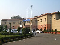
Terminal building of Safdarjung Airport
|
|||||||||||
| Summary | |||||||||||
| Airport type | Public | ||||||||||
| Operator | Airports Authority of India | ||||||||||
| Location | Aurobindo Marg, New Delhi | ||||||||||
| Elevation AMSL | 705 ft / 215 m | ||||||||||
| Coordinates | 28°35′04″N 077°12′21″E / 28.58444°N 77.20583°ECoordinates: 28°35′04″N 077°12′21″E / 28.58444°N 77.20583°E | ||||||||||
| Runways | |||||||||||
|
|||||||||||
Safdarjung Airport (IATA: N/A, ICAO: VIDD) is an airport in New Delhi, India, in the neighbourhood of the same name. Established during the British Raj as Willingdon Airfield, it started operations as an aerodrome in 1929, when it was India's second airport after the Juhu Aerodrome in Mumbai and Delhi's only airport. It was used extensively during the World War II as it was part of the South Atlantic air ferry route, and later during Indo-Pakistani War of 1947. Once situated on the edge of Lutyens' Delhi, today, it has the entire city of New Delhi around it. It remained the city's main airport till 1962, when operation shifted to Palam Airport completely by the late 1960s, as it could not support the new bigger aircraft such as jet aircraft.
The Delhi Flying Club was established here in 1928 with two de Havilland Moth aircraft named ‘Delhi’ and ‘Roshanara’. The airport functioned until 2001, however in January 2002, due to security considerations in the post 9/11 scenario, the government closed the airport for flying activities, the club only carries out aircraft maintenance courses today . Today it is mostly used for VVIP helicopter rides to the Indira Gandhi International Airport including the President and the PM. The 190 acre airport complex, has Rajiv Gandhi Bhawan on its grounds, which houses the Ministry of Civil Aviation as well as the headquarters of the Airports Authority of India (AAI).
...
Wikipedia
