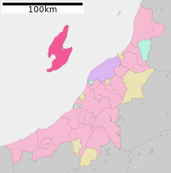
Sado, Niigata
|
Sado 佐渡市 |
||
|---|---|---|
| City | ||

Sado from the sea
|
||
|
||
 Location of Sado in Niigata Prefecture |
||
| Location in Japan | ||
| Coordinates: 38°1′N 138°22′E / 38.017°N 138.367°ECoordinates: 38°1′N 138°22′E / 38.017°N 138.367°E | ||
| Country | Japan | |
| Region | Chūbu (Kōshin'etsu) (Hokuriku) | |
| Prefecture | Niigata Prefecture | |
| Government | ||
| • Mayor | Koichiro Takano (since April 2004) | |
| Area | ||
| • Total | 855.26 km2 (330.22 sq mi) | |
| Population (April 1, 2011) | ||
| • Total | 63,231 | |
| • Density | 73.93/km2 (191.5/sq mi) | |
| Symbols | ||
| • Tree | Thujopsis | |
| • Flower | Daylily | |
| • Bird | Crested ibis | |
| • Fish | Yellowtail | |
| Time zone | Japan Standard Time (UTC+9) | |
| City hall address | 232 Chigusa, Sado-shi, Niigata-ken 952-1292 |
|
| Website | www |
|
Sado (佐渡市 Sado-shi?) is a city located on Sado Island (佐渡島 or 佐渡ヶ島, both Sadogashima) in Niigata Prefecture, in the Chūbu region of Japan. Since 2004, the city has comprised the entire island, although not all of its total area of is urbanized. Sado is the sixth largest island of Japan in area following the four main islands and Okinawa Island (excluding the Northern Territories).
As of April 1, 2011, the city has an estimated population of 63,231 and a population density of 73.93 persons per km2. The total area is 855.26 km2.
The island consists of two parallel mountain ranges running roughly southwest– and two riversnortheast, enclosing a central plain. The Ōsado (大佐渡?) range, in the north, is slightly higher, with peaks of Mount Kinpoku (金北山?), the highest point of the island at 1,172 metres (3,845 ft), Mount Kongō, Mount Myōken, and Mount Donden. Kosado (小佐渡?) range in the south faces the Honshu coast. The highest point in Kosado is Ōjiyama (大地山?) at 645 m.
...
Wikipedia


