Sabha District
| Sabha (سبها) | |
| District | |
| Country | |
|---|---|
| Capital | Sabha |
| Area | 15,330 km2 (5,919 sq mi) |
| Population | 134,162 (2006) |
| Density | 9/km2 (23/sq mi) |
|
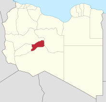
Map of Libya with Sabha district highlighted
|
|
Sabha (Arabic: سبها Sabhā) is one of the districts of Libya. It is located near the center of the country, in the Fezzan region. The capital is the city of Sabha. Sabha District borders the following districts, namely, Wadi Al Shatii in north, Al Jufrah in east, Murzuq in south and Wadi Al Hayaa in the west.
Per the census of 2012, the total population in the region was 157,747. The average size of the household in the country was 6.9. There were totally 22,713 households in the district, with 20,907 Libyan ones. The population density of the district was 1.86 persons per sq. km.
Sabha District borders the following districts, namely, Wadi Al Shatii in north, Al Jufrah in east, Murzuq in south and Wadi Al Hayaa in the west. Sabha District is in the Fezzen region (Libyan Desert), a section of the Sahara Desert. The Sabha Air Base is in the district. The Gaberoun oasis, on a spring fed lake, is a popular tourist attraction in the district. Libya has mostly a flat undulating plain and occasional plateau, with an average elevation of around 423 m (1,388 ft). Around 91 per cent of the land is covered by desert, with only 8.8 per cent agricultural land (with only 1 % arable lands) and 0.1 per cent of forests. The climate is desert in most parts of the district. Dust storms lasting four to eight days is pretty common during Spring. Triplotania is the northwest region, while it is Cyrenacia in the east and Fezzen in southwest. Fezzen is mostly full of deserts. The region receives an annual rainfall of 2.5 in (64 mm). There are no perennial rivers in the region, but the region is abundant with groundwater aquifers.
...
Wikipedia


