Sōsa, Chiba
|
Sōsa 匝瑳市 |
|||
|---|---|---|---|
| City | |||
|
|||
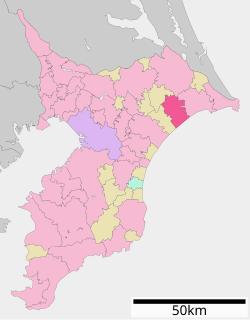
 Location of Sōsa in Chiba Prefecture |
|||
| Coordinates: 35°42′27″N 140°33′51″E / 35.70750°N 140.56417°ECoordinates: 35°42′27″N 140°33′51″E / 35.70750°N 140.56417°E | |||
| Country | Japan | ||
| Region | Kantō | ||
| Prefecture | Chiba Prefecture | ||
| Government | |||
| • Mayor | Yasunori Ohta | ||
| Area | |||
| • Total | 101.78 km2 (39.30 sq mi) | ||
| Population (April 1 2012) | |||
| • Total | 39,379 | ||
| • Density | 387/km2 (1,000/sq mi) | ||
| Time zone | Japan Standard Time (UTC+9) | ||
| Symbols | |||
| -tree | Podocarpus macrophyllus | ||
| • Flower | Tulip | ||
| • Bird | Japanese bush-warbler | ||
| Phone number | 0479-73-0084 | ||
| Address | 793-2 Yōkaichiba Sasakawa Sōsa-shi, Chiba-ken 285-8510 | ||
| Website | City of Sōsa | ||
Sōsa (匝瑳市 Sōsa-shi?) is a city located in northeastern Chiba Prefecture, Japan.
As of April 2012, the city has an estimated population of 39,379 and a population density of 387 persons per km2. The total area is 101.78 km2.
Sōsa is located in far northeastern Chiba Prefecture. It is bordered to the north by the Pacific Ocean on the southwest. The land is mostly flat, and much is from 40–50 meters above sea level in average elevation.
The northern section, a mixture of valleys, ports and rice fields, consists of a plateau made up of complicated terrain and features. The southern half consists of flat terrain facing Kujūkuri Beach.
Through the center of the city runs both the Japan Railways (JR) Sōbu Main Line and Japan National Route 126, which run east-west. To the west of the center of Sosa is Japan National Route 296, which runs north-south.
Sōsa was founded on January 23, 2006 as a result of the merger between the former city of Yōkaichiba, and the former town of Nosaka (from Sōsa District).
...
Wikipedia


