São Lourenço do Sul
| São Lourenço do Sul | |||
|---|---|---|---|
| Municipality | |||
|
|||
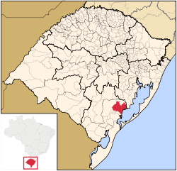
 Location within Rio Grande do Sul |
|||
| Location in Brazil | |||
| Coordinates: 31°22′02.14″S 51°58′46.37″W / 31.3672611°S 51.9795472°W | |||
| Country |
|
||
| Region | South | ||
| State | Rio Grande do Sul | ||
| Founded | 26 April 1884 | ||
| Government | |||
| • Mayor | Rudinei Harter (PDT); (2017–2020) | ||
| Area | |||
| • Total | ? km2 (? sq mi) | ||
| Population (2016 (estimate)) | |||
| • Total | 44,561 | ||
| Time zone | UTC-3 (UTC-3) | ||
| • Summer (DST) | UTC-2 (UTC-2) | ||
| Postal Code | 96170-000 | ||
| Website | http://www.saolourencodosul.rs.gov.br/ | ||
São Lourenço do Sul is a Brazilian municipality in the state of Rio Grande do Sul. The municipality had 43111 inhabitants in the last Census (2010). Its population in 2016 was estimated in 44,561 inhabitants. It is located at the west bank of the big lagoon Lagoa dos Patos.
The municipality contains part of the 7,993 hectares (19,750 acres) Camaquã State Park, created in 1975.
http://www.saolourencodosul.rs.gov.br/
31°22′02.14″S 51°58′46.37″W / 31.3672611°S 51.9795472°W
Coordinates: 31°21′55″S 51°58′42″W / 31.36528°S 51.97833°W
...
Wikipedia


