São Carlos
| São Carlos | |||
|---|---|---|---|
| Municipality | |||
| The Municipality of São Carlos | |||

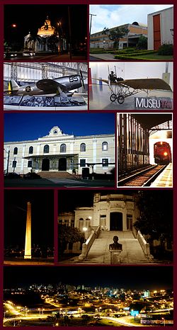
Views of São Carlos, Top left:Night view of São Carlos Cathedral, Top right:Federal University of São Carlos, 2nd:Planes display in Wings of a Dream Museum, P-47D Thunderbolt(left), Santos Dumont Demoiselle(right), Middle:São Carlos Railroad Station, Entrance Building(left), track and platform(right), 4th left:Chamine Garden, 4th right:Alvaro Guiao School, Bottom:Night view of Downtown São Carlos from Iguatemi Shopping Mall
|
|||
|
|||
| Nickname(s): The Capital of Technology, Weather City and Sanca |
|||
| Motto: "A bandeirantibus venio" (Latin) "Proceed from bandeirantes" |
|||
 Location in the São Paulo state. |
|||
| Location in Brazil | |||
| Coordinates: 22°01′04″S 47°53′27″W / 22.01778°S 47.89083°W | |||
| Country |
|
||
| Region | Southeast | ||
| State |
|
||
| Founded | November 4, 1857 | ||
| Incorporated | 1880 | ||
| Government | |||
| • Mayor | Airton Garcia (PSB) | ||
| Area | |||
| • Municipality | 1,137.30 km2 (439.11 sq mi) | ||
| • Urban | 67.25 km2 (25.97 sq mi) | ||
| Elevation | 856 m (2,808.4 ft) | ||
| Population (2010/IBGE) | |||
| • Municipality | 221,950 | ||
| • Density | 195.15/km2 (505.4/sq mi) | ||
| Time zone | UTC-3 (UTC-3) | ||
| • Summer (DST) | UTC-2 (UTC-2) | ||
| Website | saocarlos.sp.gov.br - São Carlos' Prefecture | ||
| HDI (2000) 0.841 – high | |||
Coordinates: 22°01′04″S 47°53′27″W / 22.01778°S 47.89083°W
São Carlos (Saint Charles, in English, Portuguese pronunciation: [sɐ̃w̃ ˈkaʁlus]; named after Saint Charles Borromeo) is a city of 221,950 inhabitants (IBGE/2010) in the state of São Paulo, Brazil. It is located at 22°01′04″S 47°53′27″W / 22.01778°S 47.89083°W, at about 231 km from the city of São Paulo.
The region started to be settled in the end of the 18th century, with the opening of a road that led to the gold mines in Cuiabá and Goiás. Leaving from Piracicaba, passing through Rio Claro, the hills, fields and by typical vegetations of the Brazilian countryside, settlers established in the region. São Carlos' history started in 1831, when the "Pinhal" (Pines) allotment was demarcated.
...
Wikipedia


