Sárbogárd
| Sárbogárd | ||
|---|---|---|

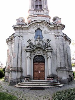
Sárhatvan Chapel of Sárbogárd
|
||
|
||
| Location of Sárbogárd | ||
| Coordinates: 46°53′16″N 18°37′10″E / 46.88776°N 18.61932°ECoordinates: 46°53′16″N 18°37′10″E / 46.88776°N 18.61932°E | ||
| Country |
|
|
| County | Fejér | |
| Area | ||
| • Total | 189.34 km2 (73.10 sq mi) | |
| Population (2009) | ||
| • Total | 12,922 | |
| • Density | 70.94/km2 (183.7/sq mi) | |
| Time zone | CET (UTC+1) | |
| • Summer (DST) | CEST (UTC+2) | |
| Postal code | 7000 | |
| Area code(s) | 25 | |
| Website | www |
|
Sárbogárd (German: Bochart) is a town in Fejér county, Hungary. The town is at the intersection of important railroad routes in Hungary: this is where electrified routes from Balaton and Pécs merge with non-electrifed railways from Baja and Szekszárd. A double electrified track runs from Sárbogárd to Budapest allowing MÁV trains to provide quick access to the capital.
Sárbogárd is twinned with:
The map of Sárbogárd from the First Military Mapping Survey of Austria Empire.
The map of Sárbogárd from the Second Military Mapping Survey of Austria Empire.
The map of Sárbogárd from the 3rd Military Mapping Survey of Austria Empire.
...
Wikipedia


