Rusk County, Wisconsin
| Rusk County, Wisconsin | |
|---|---|
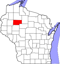
 Location in the U.S. state of Wisconsin |
|
 Wisconsin's location in the U.S. |
|
| Founded | 1901 |
| Named for | Jeremiah McLain Rusk |
| Seat | Ladysmith |
| Largest city | Ladysmith |
| Area | |
| • Total | 931 sq mi (2,411 km2) |
| • Land | 914 sq mi (2,367 km2) |
| • Water | 17 sq mi (44 km2), 1.9% |
| Population | |
| • (2010) | 14,755 |
| • Density | 16/sq mi (6/km²) |
| Congressional district | 7th |
| Time zone | Central: UTC-6/-5 |
| Website | www |
Rusk County is a county in the U.S. state of Wisconsin. As of the 2010 census, the population was 14,755. Its county seat is Ladysmith.
Founded in 1901, Rusk County was originally named Gates County after Milwaukee land speculator James L. Gates. It was renamed Rusk County in 1905 after Jeremiah M. Rusk, governor of Wisconsin and the first U.S. Secretary of Agriculture. It was formed out of the northern portion of Chippewa County.
According to the U.S. Census Bureau, the county has a total area of 931 square miles (2,410 km2), of which 914 square miles (2,370 km2) is land and 17 square miles (44 km2) (1.9%) is water.
As of the census of 2000, there were 15,347 people, 6,095 households, and 4,156 families residing in the county. The population density was 17 people per square mile (6/km²). There were 7,609 housing units at an average density of 8 per square mile (3/km²). The racial makeup of the county was 97.69% White, 0.51% Black or African American, 0.42% Native American, 0.26% Asian, 0.10% Pacific Islander, 0.35% from other races, and 0.66% from two or more races. 0.76% of the population were Hispanic or Latino of any race. 32.7% were of German, 13.6% Polish, 9.0% Norwegian, 6.8% Irish, 6.2% American and 5.6% English ancestry according to Census 2000.
...
Wikipedia
