Runnells, Iowa
| Runnells, Iowa | |
|---|---|
| City | |
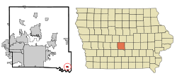
 Location of Runnells, Iowa |
|
| Coordinates: 41°30′45″N 93°21′25″W / 41.51250°N 93.35694°WCoordinates: 41°30′45″N 93°21′25″W / 41.51250°N 93.35694°W | |
| Country |
|
| State |
|
| County | Polk |
| Government | |
| • Type | Mayor/Council |
| • Mayor | Jerry Lane |
| Area | |
| • Total | 0.43 sq mi (1.11 km2) |
| • Land | 0.43 sq mi (1.11 km2) |
| • Water | 0 sq mi (0 km2) |
| Elevation | 807 ft (246 m) |
| Population (2010) | |
| • Total | 507 |
| • Estimate (2012) | 514 |
| • Density | 1,179.1/sq mi (455.3/km2) |
| Time zone | Central (CST) (UTC-6) |
| • Summer (DST) | CDT (UTC-5) |
| ZIP code | 50237 |
| Area code(s) | 515 |
| FIPS code | 19-69240 |
| GNIS feature ID | 0460848 |
Runnells is a city in Polk County, Iowa, United States. The population was 507 at the 2010 census. It is part of the Des Moines–West Des Moines Metropolitan Statistical Area.
Runnells incorporated as a city on May 21, 1903. It was named for John S. Runnells, a former editorial writer for the Iowa State Register and private secretary for Governor Samuel Merrill.
Runnells is located at 41°30′45″N 93°21′25″W / 41.51250°N 93.35694°W (41.512450, -93.357063).
According to the United States Census Bureau, the city has a total area of 0.43 square miles (1.11 km2), all of it land.
As of the census of 2010, there were 507 people, 179 households, and 135 families residing in the city. The population density was 1,179.1 inhabitants per square mile (455.3/km2). There were 187 housing units at an average density of 434.9 per square mile (167.9/km2). The racial makeup of the city was 97.0% White, 0.2% African American, 0.8% Native American, 0.4% Asian, 0.2% from other races, and 1.4% from two or more races. Hispanic or Latino of any race were 1.4% of the population.
...
Wikipedia
