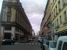
Rue de la Chaussée-d'Antin

rue de la Chaussée d'Antin with the Trinity church in the background
|
|
| Arrondissement | 9th |
|---|---|
| Quarter | Chaussée-d'Antin |
| From | 2 Boulevard des Capucines |
| To | 73 Rue Saint-Lazare |
| Construction | |
| Denomination | 1712 |
Coordinates: 48°52′26″N 2°19′58″E / 48.87389°N 2.33278°E
This "quartier" of Paris got its name from the rue de la Chaussée-d'Antin in the 9th arrondissement of Paris. It runs north-northwest from the Boulevard des Italiens to the Église de la Sainte-Trinité.
In the 17th century the chemin des Porcherons crossed a swampy piece of ground north of the porte Gaillon, a city gate in the wall built during the reign of Louis XIII, leading to the village of Les Porcherons. It is called a chaussée because the marshy ground required raised construction that ran along the top of a sort of dyke.
At the rue de Provence it crossed the "great sewer" or Ruisseau de Ménilmontant, which was approximately two meters wide.
Under an ordinance dated 4 December 1720, the street was graded and resurveyed as a wider boulevard with a width of eight toises and extended to meet the grands boulevards to the south. This new boulevard stretched from the end of Rue Louis-le-Grand to Rue Saint-Lazare.
The frequent stays of Louis XV in Paris ledto the building of splendid homes such as that of Louis Antoine de Pardaillan de Gondrin, the Duke of Antin (1665–1736). Son of the marquise de Montespan, the duke was the superintendent of the Bâtiments du Roi, or buildings of the king. His residence faced this street and his name became associated with it as early as 1712.
...
Wikipedia

