Rucphen
| Rucphen | |||
|---|---|---|---|
| Municipality | |||

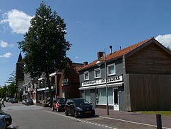
Street through Rucphen
|
|||
|
|||
 Location in North Brabant |
|||
| Coordinates: 51°32′N 4°35′E / 51.533°N 4.583°ECoordinates: 51°32′N 4°35′E / 51.533°N 4.583°E | |||
| Country | Netherlands | ||
| Province | North Brabant | ||
| Government | |||
| • Body | Municipal council | ||
| • Mayor | Marjolein van der Meer-Mohr (VVD) | ||
| Area | |||
| • Total | 64.47 km2 (24.89 sq mi) | ||
| • Land | 64.41 km2 (24.87 sq mi) | ||
| • Water | 0.06 km2 (0.02 sq mi) | ||
| Elevation | 10 m (30 ft) | ||
| Population (February 2017) | |||
| • Total | 22,214 | ||
| • Density | 345/km2 (890/sq mi) | ||
| Demonym(s) | Rucphenaar | ||
| Time zone | CET (UTC+1) | ||
| • Summer (DST) | CEST (UTC+2) | ||
| Postcode | 4710–4722, 4735 | ||
| Area code | 0165 | ||
| Website | www |
||
Rucphen (![]() pronunciation ) is a municipality and a town in the southern Netherlands between Roosendaal and Etten-Leur, south of the railway, but without a train-station.
pronunciation ) is a municipality and a town in the southern Netherlands between Roosendaal and Etten-Leur, south of the railway, but without a train-station.
Dutch Topographic map of the municipality of Rucphen, June 2015
...
Wikipedia


