Ružomberok
| Ružomberok | ||
| town | ||
|
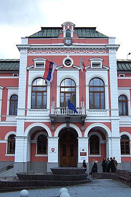
Town hall of Ružomberok
|
||
|
|
||
| Country | Slovakia | |
|---|---|---|
| Region | Žilina | |
| District | Ružomberok | |
| Tourism region | Liptov | |
| River | Váh | |
| Elevation | 494 m (1,621 ft) | |
| Coordinates | 49°04′43″N 19°18′30″E / 49.07861°N 19.30833°ECoordinates: 49°04′43″N 19°18′30″E / 49.07861°N 19.30833°E | |
| Area | 126.72 km2 (49 sq mi) | |
| Population | 29,906 (2006-12-31) | |
| Density | 237/km2 (614/sq mi) | |
| First mentioned | 1233 | |
| Mayor | Igor Čombor | |
| Timezone | CET (UTC+1) | |
| - summer (DST) | CEST (UTC+2) | |
| Postal code | 034 01 | |
| Phone prefix | 421-44 | |
| Car plate | RK | |
| Statistics: MOŠ/MIS | ||
| Website: http://www.ruzomberok.eu/en/ | ||
Ružomberok (Slovak pronunciation: [ˈruʒomberok]; German: Rosenberg; Hungarian: Rózsahegy; Polish: Rużomberk) is a town in northern Slovakia, in the historical Liptov region. It has a population of around 30,000 (45,000 with nearby villages)
It is situated at the westernmost reaches of the Sub-Tatra Basin, more exactly its subdivision Liptov Basin, surrounded by the mountain ranges of Chočské vrchy, Greater Fatra and Low Tatras. Rivers flowing through the town are Váh, from east to west, Revúca, a left tributary from the south, on the way to Banská Bystrica and Likavka brook from the north, on the way to Dolný Kubín. The town is located around 65 km from Žilina, 190 km from Košice and 260 km from Bratislava (by road). Besides the main settlement, it also has "city parts" of Biely Potok, Černová, Hrboltová and Vlkolínec.
The climate is moderate, varies from hot in summer, to very cold in winter. There are four distinct seasons: spring (wet, moderate warm), summer (hot, very wet), autumn (dry) and winter (very cold). Ružomberok is located in the rain shadow of the mountain ranges of Greater Fatra and Chočské vrchy. Total annual precipitation is 727 mm. Annual average of days with snow cover is 68. The highest snow cover ever recorded was 92 cm. Extreme temperatures: high: 37 °C (99 °F) (2007), low: −38 °C (−36 °F) (1949, 1986).
From the second half of the 10th century until 1918, it was part of the Kingdom of Hungary. The first written mention about settlement was in 1233 as terra Reuche. The town was established by Germans, who named it Rosenberg. It got its town rights in 1318. In 1340, Hungarian King Charles Robert confirmed its town rights and extended more. However, its growth was interrupted as it was placed under Likavka rule.
...
Wikipedia


