Route 29A (New Jersey)
| Route 29 | |||||||
|---|---|---|---|---|---|---|---|
 |
|||||||
| Route information | |||||||
| Maintained by NJDOT and Hunterdon County | |||||||
| Length: | 34.76 mi (55.94 km) | ||||||
| Existed: | 1927 – present | ||||||
| Tourist routes: |
|
||||||
| Major junctions | |||||||
| South end: |
|
||||||
|
|
|||||||
| North end: |
|
||||||
| Location | |||||||
| Counties: | Mercer, Hunterdon | ||||||
| Highway system | |||||||
|
|||||||
| Route 165 | |
|---|---|
| Location: | Lambertville |
| Length: | 0.26 mi (0.42 km) |
New Jersey State Highway Routes
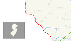
Route 29 is a state highway in the U.S. state of New Jersey. It runs 34.76 mi (55.94 km) from an interchange with Interstate 295 (I-295) in Hamilton Township in Mercer County, where it continues as I-195, to Route 12 (Bridge Street / Race Street) in Frenchtown, Hunterdon County. Between the southern terminus and I-95, the route is a mix of freeway and four-lane divided highway that runs along the Delaware River through Trenton. This section includes a truck-restricted tunnel that was built along the river near historic houses and Riverview Cemetery. North of I-95, Route 29 turns into a scenic and mostly two-lane highway. North of the South Trenton Tunnel, it is designated the Delaware River Scenic Byway, a New Jersey Scenic Byway and National Scenic Byway, that follows the Delaware River in mostly rural sections of Mercer County and Hunterdon County. The obsolete Delaware & Raritan Canal usually stands between the river and the highway. Most sections of this portion of Route 29 are completely shaded due to the tree canopy. Route 29 also has a spur, Route 129, which connects Route 29 to U.S. Route 1 (US 1) in Trenton.
...
Wikipedia

